

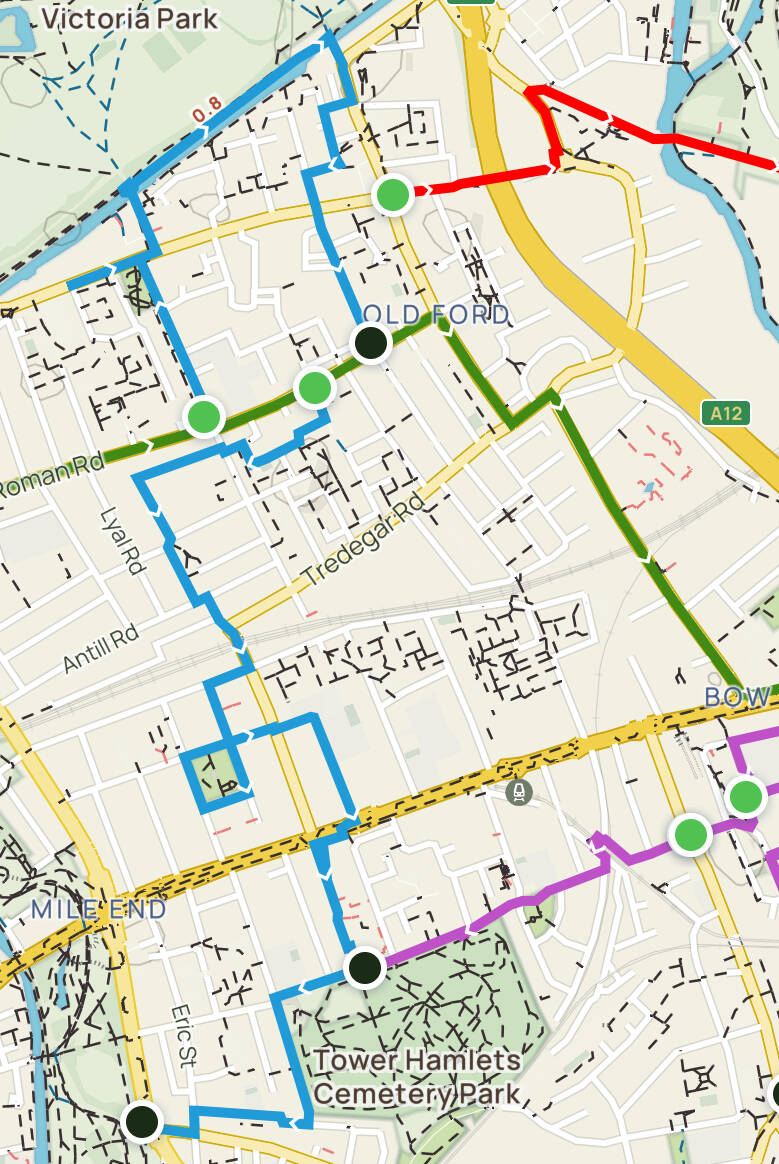
BETHNAL GREEN, BOW, BROMLEY-BY-BOW
On the map, I point out the crossroads, where ROMAN ROAD meets GROVE ROAD. You are living BETHNAL GREEN behind you, if you are going to BOW

BETHNAL GREEN
On the map the church of ST.MATHEW’S, BETHNAL GREEN. You just have left behind BRICK LANE


Buses 8 and 388 take you alongside the ROMAN ROAD
Buses from/to BETHNAL GREEN
BETHNAL GREEN ROAD: from BRICK LANE to BETHNAL GREEN


BETHNAL GREEN ROAD. Former dental factory?. Is it a coincidence that CLAUDIUS ASH, the foremost manufacturer of dentures was born in BETHNAL GREEN?

CLAUDIUS ASH’s factory was in fact in KENTISH TOWN. Now, apartments
Remember that route from BRICK LANE, passing through the churchyard of ST.MATHEW'S.
From BRICK LANE you can also take the 8 or 388, or you can walk, along BETHNAL GREEN ROAD and you will find all sorts of eateries, cafés, pubs and shops. The KOREAN POP fans-hops, the ESPACIO GALLERY…
Then you will arrive to where the street MARKET pitches start, and E.PELLICI, a café run, as has always been traditional in 20th c. London, by an Italian family, conserving as well its 1950's furniture style. As it is one of the few remaining historic cafés , it has become more of a place of pilgrimage: no way of finding a table at weekends!.
ST.JAMES’S THE GREAT Church, where REGGIE KRAY married, has become now residential.
Diversion to BROADWAY MARKET
If you follow POLLARD ROW (street), you will pass the former WORKING MEN'S CLUB, on the right, and a former DISPENSARY, now apartments, on the left.
This modern WORKING MEN’S CLUB incarnation is definitely very different from the original one, intended as a place to obtain a bit of social life, some learning and cheap drinks.
Continuing north, make sure you go alongside the HACKNEY RD., and then enter THE OVAL. You will find a few eateries along the way, then the CONTAINERVILLE workspaces, , and the old gas works, and modern residential development, where an 18th c. house has been preserved, before reaching the REGENT'S CANAL and, on the other side, BROADWAY MARKET, in about 20 min.

BROADWAY MARKET, but not in a market day!
BETHNAL GREEN TOWN CENTRE
On the map, the ST.JOHN ON BETHNAL GREEN CHURCH

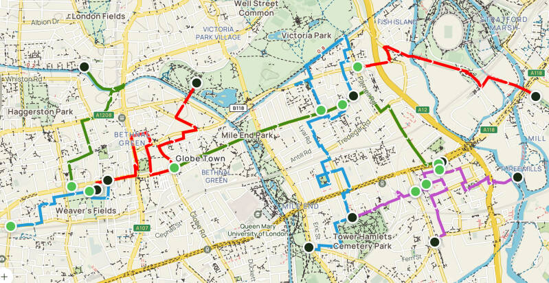
WESTWARDS: Red route to VICTORIA PARK. Green to BOW
At the Eastern end of BETHNAL GREEN ROAD, leaving the market behind, at the crossroads, you will immediately see ST.JOHN'S CHURCH (1828] an architectural design of the great SIR JOHN SOANE, better known for his project of the BANK OF ENGLAND building. Here, he came up with an eccentric squat tower. This parish is an Anglo-Catholic one. The STATIONS OF THE CROSS are by CHRIS GOLLON (2000].
If you are here with children, do not miss the YOUNG V&A, which used to be called MUSEUM OF CHILDHOOD; after the Church and the gardens, walking North, you will be there in 5 min.
It houses the national collection of childhood-related objects, dating from the 17th c.
This museum has been here since 1872, although focused on children since the 1920s. The framework of the building is a section of the IRON BUILDING, part of the SOUTH KENSINGTON MUSEUM (the first V&A).I was re-erected here in 1866.
Along the sides of the building, the MOSAICS, representing Agriculture, Art and Science were designed by FRANK MOODY, and made by female students of the SOUTH KENSINGTON MUS. supervised by MINTON. The floor inside was laid out by female prisoners.
Opposite the MUSEUM GARDENS, PARADISE GARDENS and ROW are worth a look. In one the Georgian style terraced houses you will see a plaque in memory of an English heavyweight boxer, descended from PORTUGUESE MARRANOS, DANIEL MENDOZA (sometimes, MENDONÇA or MENDOÇA). In London, a few pugilists are commemorated in plaques; but the “father as English boxing” has got two memorials, the other one being close to the cemetery where he was buried, within ST.MARY’S-UNIVERSITY OF LONDON>>>>. Despite having written his ART OF BOXING, his fame and his many wins he died penniless in 1836.
And a little further north, along the arches of the train viaduct you will find interesting places to eat and drink.
Again on the East side of the road, on OLD FORD ROAD, YORK HALL, the public baths, now a leisure centre, has been a traditional scene of boxing matches. Next door, in ST.MARGARET HOUSE, a former SETTLEMENT, there is a very charming café.
A little further north, on PATRIOT STREET, you will find the old TOWN HALL which is now a hotel. There is here another reference to the BLIND BEGGAR, in one of the sculptures on the outside wall.
The main road, CAMBRIDGE HEATH ROAD, further on to the North called MARE STREET, takes you very close to BROADWAY MARKET and to HACKNEY. Buses 106 and 254 go in that direction. Bus 254 can take you to STAMFORD HILL, where a sizeable ULTRA-ORTHODOX Jewish community lives.
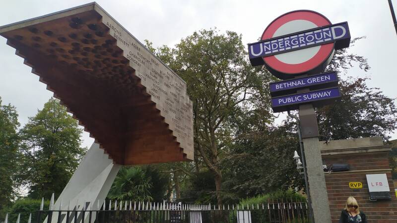
MEMORIAL: STAIRWAY TO HEAVEN
Back at the cross roads. You can inspect BETHNAL GREEN GARDENS. The public library occupies a building that used to be part of a mental asylum. There is interesting decoration, inside.
However the most important sight here, a very moving monument, is the MEMORIAL to the victims of an avalanche that happened precisely here, at this entrance of the LU station (CENTRAL LINE), in 1943, when hundreds of people, mistaking a sound they were hearing for a AIR RAID SIREN, precipitated into the the tube station (not still in service, and used as a shelter during the BLITZ). 142 people died.
Proper air raid shelters were built since the outbreak of the world, for example under some of London’s garden squares, parks and commons. But the public took to use the deep tube stations, as they felt they were pretty safe.
Thea artist HENRY MOORE did some sketches about life inside BELSIZE PARK LU station during the bombings…
Along the ROMAN ROAD to BOW. But, what about a diversion towards VICTORIA PARK?
On the map, STAIRWAY TO HEAVEN MEMORIAL. VICTORIA PARK is very close, as it is MILE END PARK, and then BOW

APPROACH ROAD. RAINE’S SCHOOL
ROMAN ROAD. Former FIRE STATION

Again, the fictional character, THE BLIND BEGGAR OF BETHNAL GREEN, an artwork by ELIZABETH FRINK.
CRANBROOK ESTATE. Designed by SKINNER, BAILEY & LUBETKIN (1964) as a utopian dream, but became wan and run down. Definitely,the place have been improved, after becoming a film location…
If you walk ROMAN ROAD and reach the old fire brigade headquarters, which is now a Buddhist centre , you will pass a couple of cafés, and a couple more after you turn left. You will like the atmosphere of these surroundings, especially at weekends. After the fire brigade, amongst the interesting places you will find FOUR CORNERS, where photography and cinema related exhibitions are free.
Possible diversion:
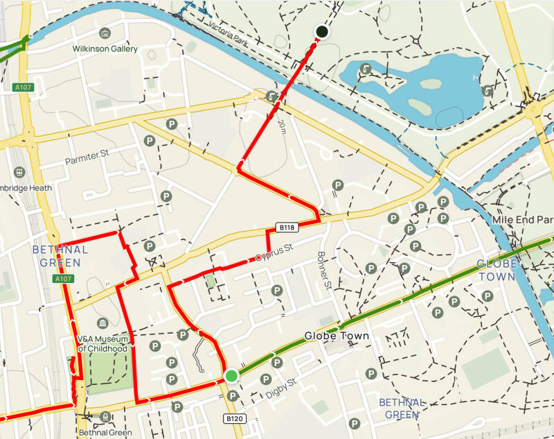
If you continue walking GLOBE ROAD (by the way, this area is known as GLOBE TOWN) towards the North, you could walk to VICTORIA PARK in 20 m. At the BONNER GATE, one of the entrances to the park, a FARMERS' MARKET is held on Sundays, and you will be greeted by the DOGS OF ALCIBIADES>>>>. On your way, do not miss, in CYPRUS STREET an unexpected, unlikely, war memorial. Then try to find on APPROACH ROAD, the contemporary RAINE’S SCHOOL (in WAPPING you will see the original building), and the former CHEST HOSPITAL, pending development).
If you fancy walking to BOW, alongside the ROMAN ROAD (maybe you are following the same path that the Roman legions did!), you will pass by another BLIND BEGGAR (an statue by ELIZABETH FRINK), inside de CRANBROOK ESTATE, designed, amongst other architects, by BERTHOLD LUBETKIN. Then over the >>>>REGENT’S CANAL and MILE END PARK, and once you cross over GROVE ROAD, ROMAN ROAD becomes more commercial. You can enjoy a good walk towards the market.
Before, note 182 GROVE RD. the building you see, to the left, when crossing the road, housed one of DR. BARNARDO’S HOMES for children. And the churches.

From BETHNAL GREEN:
Bus 388 takes you to VICTORIA PARK and the OLYMPIC PARK>>>> and stops at CAMBRIDGE HEATH ROAD.
106 and 254 to HACKNEY.
In ROMAN RD,
the 309 takes you to POPLAR.>>>> And the D6 to MILE END, to POPLAR>>>> and to MILLWALL DOCK, ISLE OF DOGS>>>>
On BETHNAL GREEN ROAD, for the 388, and the D3, SHADWELL>>>>, LIMEHOUSE>>>>, CANARY WHARF>>>>, and TRINITY BUOY WHARF>>>>. And on bus 8 to BOW>>>>.


BETHNAL GREEN ROAD. The end of market day

And that was BETHNAL GREEN

BOW
On the map, ROMAN ROAD, the section where the street market begins

A typical East London dish, consisting of meat pie, with mashed potatoes, with a meat sauce or a parsley-based one, the latter called LIQUOR. Take advantage, because there are very few left
Jellied eels, another East End speciality

Yes, alongside the BETHNAL GREEN RD. if you are on a number 8 bus you will arrive at BOW, after crossing the REGENT'S CANAL and MILE END PARK.
If you get off the bus when ROMAN ROAD turns into a typical Eastender street MARKET, you will enjoy it immediately. If you got off earlier, it doesn't matter: there are shops and cafes along the road.
And, once you walk along the market street, you will find a G. KELLY’S RESTAURANT (only pie and mash, and jellied eels). A, then, you will get to the old PUBLIC LIBRARY (a PASSMORE EDWARD’s one) that has been added and improved by DAVID ADJAYE, as an IDEA STORE.


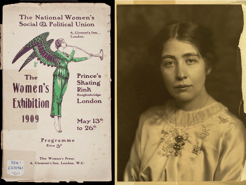
The suffragettes were a militant movement, real activists, and, as such, were fiercely repressed by the authorities

As I often say in this guide, BOW is a traditionally deprived area, which is changing, gentrifying like the entire East End. COSTA COFFEE is already here. And the posh wine shop.
Politically, this being the EAST END, you are in a a leftist, progressive territory: this is the iconic neighbourhood of the EAST END SUFFRAGETTES, led by SYLVIA PANKHURST. Its organisation was, first, the EAST LONDON branch of the WOMEN SOCIAL AND POLITICAL UNION, WSPU, which EMMELINE PANKHURST, mother of SYLVIA and CHRISTABELL, had founded in MANCHESTER.
The working class struggle was also part of the ideal of SYLVIA and her associates of East London. And the full right of vote for men. For their part, the WOMEN’S SOCIAL AND POLITICAL UNION was made up of women from more affluent classes, who, in addition, considered that uneducated men and women from the working class could not lead any movement. That is why the two sides split up and the EAST LONDON FEDERATION OF SUFFRAGETTES was created.
On this street the SUFFRAGETTES demonstrated and sold their newspaper, WOMEN'S DREADNOUGHT, in market days. DREADNOUGH… “have no fear.”
The HALL that was opposite the Library, and building next to it -the PUBLIC BATHS- were also the scene of the movement's public events. Now, postwar housing and shops occupies the site.
EMMELINE and CHRISTABEL are honoured in a MEMORIAL within VICTORIA TOWER GARDENS (WESTMINSTER). A statue is planned for SYLVIA, and crowdfunding has started. MILLICENT FAWCET has a statue in PARLIAMENT SQUARE. But the memorial pays homage to many more women and men who fought for the right to vote.
From ROMAN ROAD, you can sense the proximity of the OLYMPIC PARK>>>>: the ARCELOR-MITTAL ORBIT appears in the background, when you are walking the market.
The South of BOW: TREDEGAR SQUARE or the BRYANT & MAY MATCH FACTORY
On the map, where the toy factory was. To the South, TREDEGAR SQUARE

In blue:Towards TREDEGAR SQUARE and the CEMETERY
In green, towards BRYANT & MAY and BOW CHURCH
45 NORMAN GROVE. SUFFRAGETTES’ TOY FACTORY. The factory employed 59 women they turned out wooden toys and then dolls, stuffed cats, dogs and bears. Audaciously SYLVIA decided to take a taxi to Selfridges, she met GORDON SELFRIDGE himself and convinced him to become a stockist. Photo and text from INSPIRING CITY.


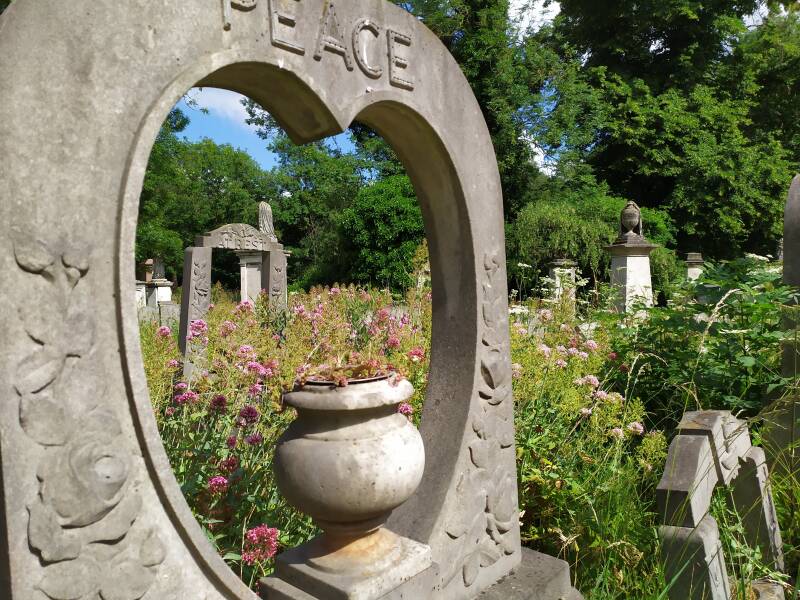
TOWER HAMLETS CEMETERY

Now, I am giving you a couple of ideas for a detour from the market to the South:
First, I would advise you to walk back ROMAN RD., towards the West, look for SAXON STREET and enter NORMAN GROVE, where the SUFFRAGETTES established their TOY FACTORY, at no. 43.
Then South, alongside SELWYN and COBORN ROADS, towards the area around TREDEGAR SQUARE and adjacent streets. The houses around the garden square are from the REGENCY era, when the neighbourhood was still, in pre-industrial times, “more respectable”.
The former COOPERS school on the corner is now residential. A charity school, originally founded in the 16th (era of foundation of many schools and almshouses in England) and placed later under the the care of the COOPERS’ LIVERY COMPANY of London. Coopers?. Think beer!.
And you will find a couple of interesting pubs in the area, like the MORGAN ARMS gastropub.
And if you continue even further south, for example following COBORN RD., passing the COBORN pub, to the main road, MILE END ROAD, you cross it and can enter the premises of the former ST.CLEMENT'S HOSPITAL, currently, and after a fantastic restoration and expansion, a residential complex. You are no longer properly in BOW, rather in BOW COMMON.
If you continue still towards the South, crossing completely this development, you will enter the TOWER HAMLETS CEMETERY PARK, one of the MAGNIFICENT SEVEN (cemeteries) of London, which are now natural parks.
The former MATCH FACTORY, now BOW QUARTER, pointed out on the map

The Green route for the former match factory
SYLVIA PANKHURST delivering a speech at 198 BOW ROAD, first HQ of the W.S.P.U. branch. Photo from INSPIRING CITY

The other detour, towards the Southeast (and in this case you can also get there on the bus 8 —the stop is at PARNELL ROAD, at the East end of the MARKET— you will find a Victorian red brick industrial complex, which is currently a rather upmarket residential development, BOW QUARTER.
It was here, at the BRYANT & MAY match factory, where in 1888, the same year of the RIPPER crimes, the girls and women who worked here - the MATCH GIRLS - staged a very notorious strike, which gave rise to the trade union movement in England. Some meetings took place at the HANBURY HALL, near BRICK LANE.
They logically fought against their labour exploitation: in addition to receiving a mediocre pay and to being handed unfair sanctions and getting an humiliating treatment, they suffered from serious illnesses caused by the handling of phosphorus.
Presenr in this workers' struggle, was, among others, ELEONOR MARX-AVELING, the daughter of KARL MARX. Instead, the philosopher never became directly involved in struggles or demonstrations. The main activist, who encouraged the unprecedented industrial action was ANNIE BESANT.
If you continue walking towards the South you will end up in the BOW ROAD, the same main road that starts at ALDGATE, but which has up to 5 different names until here.
There are some buildings of interest, on the North side, such as
the former (1938] POPLAR TOWN HALL, with lovely MOSAICS by artist DAVID EVANS, representing dock activity. Now is a BUSINESS CENTRE.
the former Branch of the c STRATFORD CO-OPERATIVE & INDUSTRIAL Society. On top, note the symbol of the co-op, the BEEHIVE.
the NUNNERY GALLERY (firmer convent)
the former little old shops, at no.223.
You will cross it and you can visit the parish church of ST.MARY AND HOLY TRINITY or simply BOW CHURCH, with some medieval parts surviving.
At its feet, you will see the STATUE OF GLADSTONE (Prime Minister during the Victorian era, one of the most influential figures then and who held power fir longest, along with BENJAMIN DISRAELI).
The GLADSTONE depicted here has red stained hands. The initiative for the erection of the memorial was that of Mr. BRYANT, the boss of the match factory, and paid for with a part of the held back wages of the MATCHGIRLS.
On the other side, where there is now a post-war social housing estate, at no. 198, was the house where the EAST END SUFFRAGETTES, still then the WSPU, established their first headquarters.
As you are on the South side of the road, you are in the BROMLEY-BY-BOW>>>>district, another of the EAST END neighbourhoods.
Buses 8, 25 and 205 are at hand. STRATFORD or the CITY and WEST END.

MANUFACTURING CHINA.
In the 18th c., somewhere around this area, South of BOW, West of RIVER LEA, were established the famous PORCELAIN FACTORIES, that would emulate the product made in CHELSEA.
Later on the factories were transferred to the other side of the LEA, where the area was called for sim3 time NEW CANTON.
To the North of BOW: towards VICTORIA PARK
I point in the map where the LIBRARY is

From the ROMAN ROAD to VICTORIA PARK, to the North
3 colts. Colt means a young horse. A few streets in the EAST END refer to THREE COLTS. Normally, in these cases, the origin of a street name lies in an old inn that used to be in the vicinity. Perhaps an inn displaying a COAT OF ARMS, where 3 colts are represented. Which noble family, in England, such coat of arms?: the COLT BARONETS

You can walk North, to OLD FORD ROAD, alongside ST STHEPHEN’S ROAD. If you fancy, enter the church of ST.PAUL, OLD FORD, which has been remodelled inside. A church is still there, for sure, but other activities take place here, and it has a lovely café.
Fromy OLD FORD RD. you have an entrance to VICTORIA PARK>>>>, through GUNMAKERS LANE (ammunition is what was produced in these factories that you are passing, hence the name), and crossing the THREE COLTS BRIDGE.
If you follow PARNELL ROAD you will cross the PARNELL ROAD BRIDGE.
These 2 bridges cross the HERTFORD & UNION CANAL, which links the REGENT'S CANAL, with the LEE NAVIGATION, at HACKNEY WICK>>>>.
Near the first entrance you will find the LORD MORPETH pub. On the west wall of the pub, there is a fantastic mural, where you will recognise SYLVIA PANKHURST, accompanied by scenes of the fight for women’s vote. Nearby, a plaque reminds us that here, the GUNMAKERS' ARMS pub was acquired by the SUFFRAGETTES and converted into a creche and restaurant at affordable prices, which allowed the women of the neighbourhood to keep their jobs. And renamed THE MOTHER’S ARMS.
One more idea, one more diversion: to FISH ISLAND, the GREENWAY and the OLYMPIC PARK

Aim for the BIG YELLOW self storage.Still an industrial estate here, but in the process of transformation
Bus 8

WW2.Pillow box.
VIEW TUBE

To the East end of OLD FORD ROAD, that road continues but almost without traffic since the road ends up leading to a cyclists and pedestrians bridge, which takes you very, very close to the beginning (on this West side) of the GREENWAY and also to FISH ISLAND>>>>.
If you look closely you will see that you will pass alongside of up to three temples, both sides of the bridge. The first one, now apartments, sports a plaque
Both sides of the roundabout you will see the bus stops ( route 339 which takes you to SHADWELL>>>> or the OLYMPIC PARK.>>>>). You will turn left on WICK LANE and, on your right, you will notice the entrance to the Western end of the GREENWAY. Instead, if you walk on, you are going to be in FISH ISLAND, which is linked to HACKNEY WICK..
The GREENWAY is a walking and cycling path that, after allowing you views of FISH ISLAND and of the OLYMPIC PARK (you will be able to enter it if you wish), will take you across the STANSTEAD MILL STREAM (is the name related to STANSTEAD MOUNTFITCHET WINDMILL?).
Attention: just before the bridge, note the WW2 PILLOW BOX; it makes sense, as an invasion was likely and the now called GREENWAY could become a road at the service of the invasor forces).
Then you will leave behind a THAMES WATER TREATMENT PLANT. Finally, the GREENWAY will take you to the VIEW TUBE, a community and educational centre, with a café and shops, almost all built with recycled ship containers. And you can even rent bikes (speak to NIGEL!). And maybe you will find, when you visit, a little farmers market.
AND the GREENWAY ends…apparently.
The path ends here, definitely, but once you have overcome, through a long but easy diversion, the railway tracks, you will rejoin it, and once you have crossed the STRATFORD HIGH STREET, the path continues uninterrupted, and the GREENWAY will take you to BECKTON, almost in a straight line, passing through a few neighbourhoods of East London, as WEST HAM, PLAISTOW or EAST HAM.
In BECKTON there is a large waste water treatment plant… and a former gas factory. No, Inknow, you are not interested in this type of sights, but what about seeing the BECKTON ALPS!. What?.
Let us be serious. In fact, while walking along the GREENWAY you are walking on top of a large sewer. The history of London’s sewers takes us to Central London, to the VICTORIA EMBANKMENT, where you are going to find a MEMORIAL to SIR JOSEPH BAZALGETTE, the chief engineer of the METROPOLITAN BOARD OF WORKS, first London wide local institution of government. Alongside the EMBANKMENT (which took land to the river THAMES) runs the famous sewer and the London Underground. Definitely, that sewer comes this way and ends up in BECKTON.
Anyway, the GREENWAY allows for a healthy an interrupted walk or ride!.
SCDS in HEWISON ROAD

Remember that you were in BOW, alongside the ROMAN ROAD MARKET.
When you are at the East end of the MARKET, on PARNELL RD, with bus 276 you can go to STRATFORD>>>> (from where you will go to the OLYMPIC PARK>>>>). BUS 8, to <<<<BOW CHURCH or towards NEW OXFORD STREET, WEST END.
On the map, the site of the HQ of the ELFS, now a residential building called ICENI COURT.
And that is it. Now you know a little more about BOW
BROMLEY-BY-BOW
On the map, the location of KINGSLEY HALL, where GANDHI stayed in 1931. To the right, BOB’S PARK,
part of the BROMLEY-BY-BOW CENTRE. You can see that BOW CHURCH is not far away to the North. To the East, TRHREE MILLS ISLAND
Again, a neighbourhood, almost certainly, that you were not specifically planning to visit but... here you have it, you never know.
Unlike you, some people come to BROMLEY-BY-BOW on purpose. For instance, GANDHI. When he came to London in 1931 to participate in discussions on future constitutional arrangements, in order to keep India within the BRITISH EMPIRE and suffocate their independence aspirations (as you well know, GANDHI was simply betting on independence), the modest leader chose to stay away from the luxury hotels of the WEST END and found this place that you are now visiting, a community centre , founded at the beginning of the 20th century by the LESTER SISTERS, and called KINGSLEY HALL, in tribute to their deceased brother, KINGSLEY LESTER. The LESTER sisters were pacifists, philanthropists and social activists, and they supported the SUFFRAGETTES.This place housed a TEA TOTAL pub, since the sisters were part of the TEMPERANCE MOVEMENT. Now, for you, there is a café open to the public.
Curiously enough, the modest GANDHI of 1931 was no longer the young dandy who studied law at the INNER TEMPLE, who, between 1888 and 1891, enjoyed high life in London, but who, finally, did not manage to work here as a BARRISTER (a type of lawyer, in COMMON LAW jurisdictions, or countries, who represents the parties in the high courts. Every barrister in England and Wales have to be member of one of the four INNS OF COURT —all four based in London, and which I encourage you to visit, as they are very charming and historic places— and formed in their shared LAW SCHOOLS).
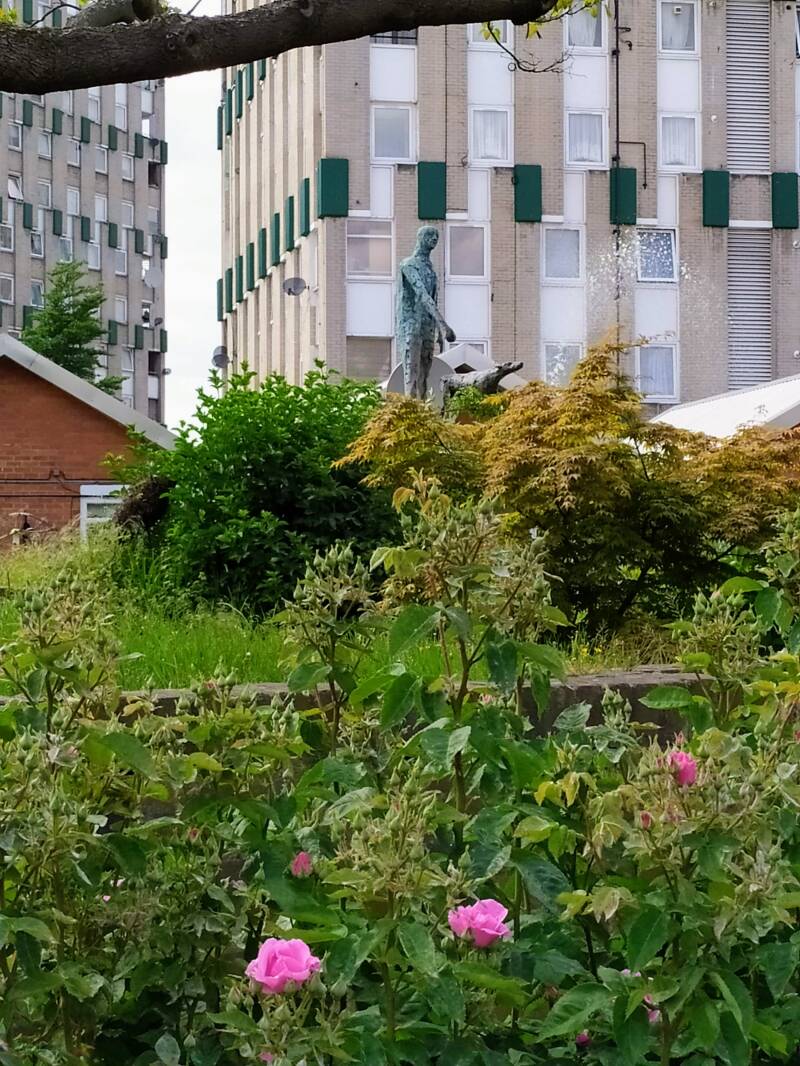
Behind KINKSLEY HALL, there is a modern community centre, where advice is provided, there is a doctor's surgery, courses for adults are offered, etc. You pass a fantastic garden, BOB'S PARK, replete with of sculptures by a local artist, PAULA HAUGHNEY, who also has a workshop here. Again, you will find a cafe.
You will leave, perhaps, through the ARCH designed by the architect WILLIAM KENT, originally at the entrance to the gardens of NORTHUMBERLAND HOUSE, an aristocratic mansion that was adjacent to TRAFALGAR SQ. (NORTHUMBERLAND AVENUE occupies part of the space previously covered by the gardens). At the end of the 19th century, beginning of the 20th century, the British aristocracy was abandoning its residences in London, but retaining its country palatial houses. In this case you have an easy task if you like visiting noble palaces: the DUKE OF NORTHUMBERLAND has his house and his gardens open to the public, in the LONDON BOROUGH OF HOUNLOW, to the West, near BRENTFORD (where you are going to see the REGENT’S CANAL, but on the opposite side of London). It is SYON HOUSE. Nearby there is another fantastic residence, OSTERLEY HOUSE. KEW GARDENS and RICHMOND are very close. Keep it in mind. Sorry for distracting you, back on BROMLEY-BY-BOW!. turn
You will find yourself on ST.LEONARD'S STREET and you can walk to the old cemetery of the parish church, which used to bear that name, ST.LEONARD, which was destroyed during the War. Originally, this area was occupied by ST.LEONARD'S PRIORY. Remember the DISSOLUTION OF THE MONASTERIES by HENRY VIII. The names of some streets of London remind us of the past existence of monasteries (I.e.BLACKFRIARS, ABBEY ROAD…). But in the CHARTERHOUSE and BART’S HOSPITAL you can still find some old stones, and above all, the institutions that succeeded the monasteries.

Buses 8, 25 and 205
Other sights in BROMLEY-BY-BOW:
DRAPERS ALMSHOUSES, HESTER SISTERS SCHOOL, ELECTRICITY STATION, BOW ROAD’S SUFFRAGETTES SITES
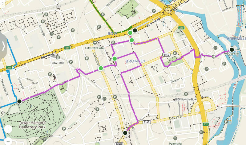
Purple line. Suggested routes.
To THREE ISLANDS
To WIDOWS SON PH, DLR STA
To TOWER HAMLETS CEMETERY & PARK


The POWER GENERATING STATION, the pedestrian RAILWAY BRIDGE and the DRAPERS ALMSHOUSES. Photos from SPITALFIELDS LIFE
On ST.LEONARD’S ST. the D8 bus takes you to STRATFORD>>>> or CANARY WHARF>>>>.
Route 488 takes you to the BROMLEY-BY-BOW LU station (which, in fact, is very close) or to DALSTON, the Turkish neighbourhood already mentioned.
If you decide to continue exploring and head westwards from KINGSLEY HALL you can walk to what remains of the DRAPERS ALMSHOUSES, a small row of almshouses, from the 18th century, that survived the BLITZ, founded under the patronage of the DRAPERS Guild, now one of the CITY’s LIVERY COMPANIES.
After that, you continue West and, in TOLMINS GROVE you will find a former electricity generating station, established by the BOROUGH OF POPLAR .
From here, you can head Westwards, to the TOWER HAMLETS CEMETERY PARK.You will be there in 10 min., after crossing the railway bridge.
You can also take a detour passing by the CHILDREN'S HOUSE, another initiative, in this case a children's daycare centre, by the LESTER SISTERS. It is in BRUCE RD. Do you see the blue plaque?: the writer H.G.WELLS opened it. Now it is a nursery.
To the North, in the main road, BOW ROAD, there are some more sites that are connected to the SUFFRAGETTES, and you are going to find then easily:
BROMLEY PUBLIC HALL, where innumerable meetings took place, followed by processions
POLICE STATION, where the suffragettes were dealt with
STROUDLEY WALK, where SYLVIA gave her first speech in East London
GEORGE LANSBURY MEMORIAL, on the site where GEORGE LANSBURY’s house was
MINNIE LANSBURY MEMORIAL CLOCK
REMEMBER: bus routes 8, 25 and 205. BOW ROAD LU STATION is close by, as it is the BOW CHURCH DLR STATION.
Maybe you will find it off the mark but THE WIDOWS SON P.H. is worth a visit. A sad story awaits you… DEVONS ROAD DLR sta is next door!
Last idea: walk or to cycle THREE MILLS ISLAND
From BROMLEY-BY-BOW to the THREE MILLS a walk is going to take you 15 min. And a ride, still less. When you leave BOB’S PARK and walk to the end of WASHINGTON CLOSE you easily will find an underpass that allows you cross the highway. And immediately, are going to find a large TESCO supermarket.
Create Your Own Website With Webador