


An Introduction to EAST LONDON: STRATFORD & GREEN STREET (WEST HAM/EAST HAM)
On the map the OLD TOWN HALL, STRATFORD BRIADWAY.
GREEN STREET is were UPTON PARK is indicated on the map

WEST HAM circular walk and GREEN STREET. Both areas are linked by buses alongside the ROMFORD ROAD

Tube, Overground, Elizabeth Line, DLR.
You are going to visit 2 areas which, before of the local administration reform and the new boundaries of 1965 (1964 Act), with the formation of GREATER LONDON, used to be part of the COUNTY OF ESSEX. Back then, STRATFORD was within the boundaries of the BOROUGH OF WEST HAM. Around ALL SAINTS CHURCH lays the most ancient part of the district.
As for GREEN STREET, in fact it is the boundary between WEST and EAST HAM.
You will be now in London Borough of NEWHAM. By the way, when they reorganised the London Boroughs they came up with a new name, NEWHAM — the “new village”— a linguistic merge, as EAST HAM and WEST HAM were amalgamated and incorporated into Greater London.
And you are not anymore in the EAST END, but this is contentious, and you are going to find people in the area who recognise themselves as EASTENDERS.
NEWHAM is considered one of the poorest boroughs in ENGLAND. In fact, 10 years ago, was the most deprived one . Now, things are a little bit better, thanks to the new developments and improvements brought to the the 2012 GAMES and on the wake of them.
Anyway, you will see what life is like in the streets of a London working class, multicultural and lively neighbourhood... a neighbourhood that 20 years ago no one in London knew where it was and that no one thought about visiting. Now NEWHAM is in the maps, its modest attractions are more valued and hotels and other types of accommodation, have spring up thanks to that big attraction next door, the QUEEN ELIZABETH OLYMPIC PARK.


STRATFORD & WEST HAM
On the map, STRATFORD BROADWAY, the main thoroughfare, in front of the South exit of the SHOPPING CENTRE.
All the attractions mentioned in this guide are around this area
Public transport around STRATFORD
From CENTRAL LONDON (HOLBORN and the CITY) bus 25 brings you here, stoping on the BUS STATION and along the HIGH STREET and the ROMFORD ROAD. And bus 388, from LONDON BRIDGE, the CITY and the EAST END and VICTORIA PARK, take you to STRATFORD CITY


Train Services to/from STRATFORD STATION
I remind you that there is a huge transport hub in and around STRATFORD STATION; you can get to (and from) here on the CENTRAL and the JUBILEE LINES of the LU and on the ELIZABETH LINE to the WEST END.
You can go to the DOCKLANDS area and to the CITY on the DLR.
Interesting areas of NORTH LONDON and WEST LONDON, on the OVERGROUND
If you take bus route 25 in HOLBORN or CHEAPSIDE, you will arrive at the WHITECHAPEL ART GALLERY and BRICK LANE. Do you remember?.
Now, you have decided to continue by bus and adventure yourself on the other side the RIVER LEA.
You are heading to STRATFORD (not UPON-AVON, WARWICKSHIRE, this walk having nothing to do with SHAKESPEARE. However there are historians that have doubts about the true identity of the author of the works of "SHAKESPEARE" going so far as to open the possibility that the Shakespearean STRATFORD is this one from NEWHAM and not the one from WARWICKSHIRE. Anyway, the subject of SHAKESPEARE’s life is a very interesting one but I am going to leave it here)

Proposed circular route from the STRATFORD CENTRE, passing by what used to be the core of the WEST HAM VILLAGE, the church of ALL SAINTS
Just exiting the STRATFORD STATION (which was expanded and done up in the years prior to the GAMES) you will admire the little locomotive, ROBERT, which reminds you that this was a huge hub dedicated to the construction, repair and maintenance of locomotives and coaches. In addition to other industries, all of them smelly and pollutant. Thence the STINKY STRATFORD fame.
After seeing ROBERT, and before entering the STRATFORD CENTRE, enjoy the STRATFORD SHOAL, an artwork by STUDIO EGRET WEST (architectural practice), which is supposed to represent a long wood, of 250 m. long, made of steel, with 80 titanium leaves, that tries to hide the car park and give a touch of distinction to a building which looks a little worn out and which, with no doubt, it is going to be redeveloped in a not too distant future.
A then, you will enter the STRATFORD CENTRE , where, in addition to shops and eateries, you will find market stalls, including fruits and vegetables. A traditional street market used to be hold here, before WW2. The street was ANGEL LANE. The mall has different entrances and branches. Be advised, as you can get lost. It is worth exploring: there are a few food stores and eateries representing the community of the area, that is, the world.
In the end, a much less luxurious and sophisticated shopping centre than the WESTFIELD half a mile away, but more authentic.
The STRATFORD CENTRE site in the 19th c. See ANGEL LANE and in its triangular shaped site, ST.JOHN’S

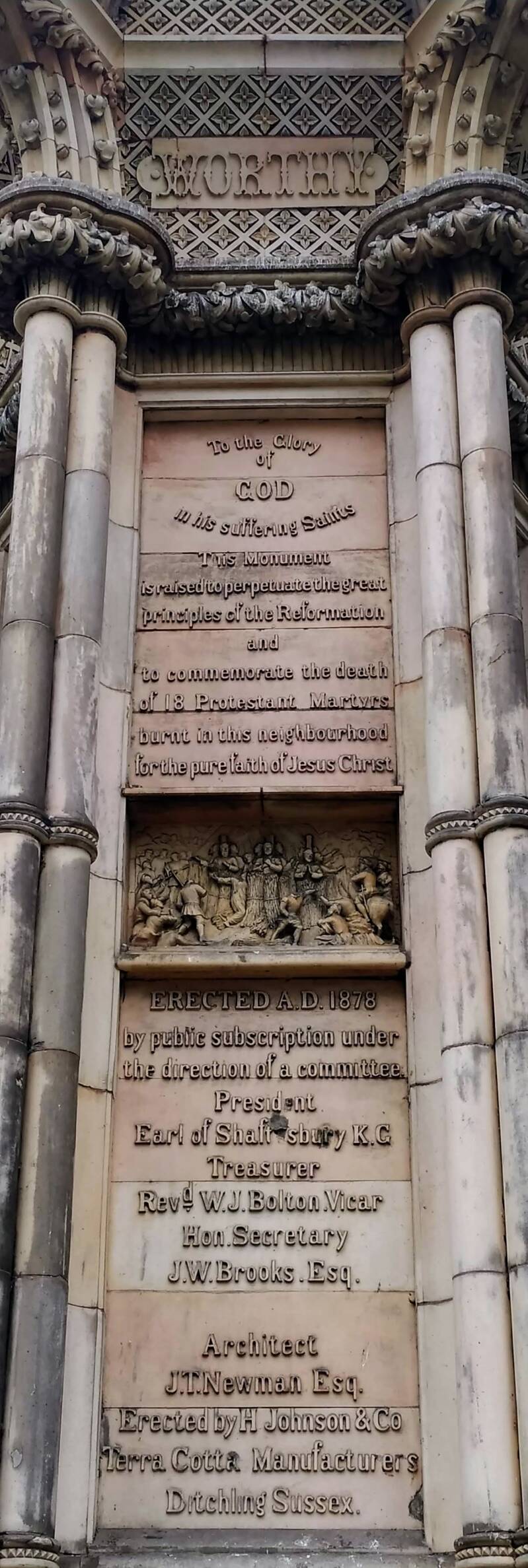
The PROTESTANT MARTYRS’ MEMORIAL
ST.JOHN’S CHURCh

If you exit the STRATFORD CENTRE through it NE, you will be reaching the THEATRE ROYAL STRATFORD EAST, saved after the War by its manager GERRY RAFFLES and the director of the THEATRE WORKSHOP COMPANY, JOAN LITTLEWOOD. He has the name of the square in his honour. She has got a statue.
There is, as well, in this cold contemporary development, a PICTUREHOUSE CINEMA and the UNIVERSITY OF EAST LONDON main THEATRE.
You will finally come out to the GROVE, where you will find the award-winning LIBRARY, and, then, to BROADWAY, the main street, where you will find, again, a small street market, including World STREET FOOD stalls, and, as well, shops, cafés and restaurants.
You can see, to the left, ST.JOHN'S CHURCH. It was designed by EDWARD BLORE, the architect responsible for converting BUCKINGHAM HOUSE in… a PALACE. In front, in the churchyard, the MEMORIAL to the PROTESTANT MARTYRS, burned at the stake, some of them in STRATFORD GREEN, a site not far away from here, during the reign of QUEEN MARY (1555).
Once inside the churchyard you can see, on the opposite site, to the right, the former STRATFORD TOWN HALL, a beautiful Victorian building that reminds us than 150 years ago the population was growing and the COUNTY BOROUGH OF WEST HAM (the authority that preceded to the formation of the modern L.B. of NEWHAM) needed new premises. STRATFORD had become the administrative centre of the County Borough.
You are going to find the current NEWHAM town hall in a modern building by the VICTORIA DOCK, when you visit the <<<<ROYAL DOCK. However, the Council meets in EAST HAM>>>>.
And, directly opposite the MEMORIAL, the EDDIE'S pub, which is the popular name in the area of the KING EDWARD VII, is waiting for you. But before 1914-it used to be the KING OF PRUSSIA… Next to it, the former LONDON & COUNTIES BANK.
Note, as well, the OBELISK erected in memory of SAMUEL GURNEY, banker and philanthropist, resident in HAM HOUSE. His daughter CATHERINE was married to SIR THOMAS FOWELL BUXTON (the brewer of SPITALFIELDS).
If you walk Eastwards, you are going to find the OLD DISPENSARY, on the ROMFORD RD. It was built in the REGENCY period (it is a timber-framed building, the weatherboarding cladding is typical of the beginning of the 1800, especially in sea towns), and it is considered the oldest building in the locality. It was in use until 1861.
Definitely, since you not see very ancient buildings, it tells you that STRATFORD is a Victorian suburb, which developed and grew in population thanks to the railways.
Precisely, those workers founded the STRATFORD SOCIETY, in 1862, which developed into the LONDON CO-OPERATIVE SOCIETY.
Opposite the OLD DISPENSARY, the former WORKING MEN’S CLUB.
In DEANERY ROAD, SYSTEM HOUSE was built as public offices.
In the corner of WATER LANE, note the STRATFORD COMMON marker
And, a little further East, the UNIVERSITY OF EAST LONDON buildings are worth a look. Originally, this was the site of the CENTRAL LIBRARY and WEST HAM TECHNICAL INSTITUTE. PASSMORE EDWARDS contributed to its foundation, and to the establishment of the MUSEUM next door, which closed in 1994. This area use to be the GALLOWS GREEN.
Return to the ROMFORD ROAD, where you are going to find beautiful Victorian vilas and terraces.
Opposite were the premises of WEST HAM ELECTRICITY BOARD, opened in 1906 and rebuilt 1927-30. These have now been converted to apartments.
Continue along Romford Road walking on the left hand side. Opposite is the BOW COUNTY COURT, built in the 1950s.
The new fire station opened in 1964. The PIGEONS PUB was built in 1898 and now houses a TESCO store.
Rght into FARADAY ROAD.
There is a new development for the Toynbee Housing Association.
Bear left at VAUGHAN ROAD then go along MATHEWS PARK AVENUE.
On the left is a BOARD SCHOOL.
Right at HAM PARK ROAD.
Some houses retain attractive path and porch tiles.

Map of WEST HAM PARK
Cross and enter WEST HAM PARK at LINDEN GATE.
LINDEN COTTAGES are to the right and a WILDLIFE GARDEN to the left. The park dates back to 1566 when it was originally part of the UPTON PARK ESTATE. From 1762-80 it was owned by philanthropist DR.JOHN FOTHERGILL who established here his BOTANICAL GARDEN. In 1812 the Quaker banker SAMUEL GURNEY acquired the property. HAM HOUSE (sometimes called UPTON HOUSE) was demolished in 1872 and the grounds sold on condition they became a public park. It has been maintained by the CORPORATION OF THE CITY OF LONDON since 1874 and is Grade II listed.
Explore the northern half at this stage and the southern half on the return. Walk to the south of the cricket pitch for VIEWS of CANARY WHARF and ST.JOHN’S Church (trees permitting!). Exit at the MARGERY GATE (NE) and go right along HAM PARK RIAD. At the end go left along UPTON LANE.
The former UPTON CROSS Church is now a glass warehouse. It had been built in the grounds of the proper la called UPTON HOUSE, residence of DR. JOSEPH LISTER, the pioneer of antiseptic surgery, born in the hamlet of UPTON.
The grounds of CLAPTON FOOTBALL CLUB (founded in 1878) were formerly a cricket pitch.
The OLD SPOTTED DOG was originally a 16th century timber-framed hall deriving its name from Henry VIII's hunting kennels. During the plague in 1603 city merchants used it as an exchange. There were additions to the building in the 19th century. Neglected for years, it seems it has a future…
Right into UPTON AVENUE.
The RED HOUSE of 1760 was remodelled in the 1880s and became ST.ANTONY’S social club.
Right along DORIS ROAD and left into UPTON LANE.
MEGGS ALMSHOUSES moved here from WHITECHAPEL ROAD in 1893.
On the right further along is a view of the PARK NURSERY. This produces some 200,000 plants for use in the City's parks and gardens and at state occasions. There is no public access but tours can be arranged with the park office.
Re-enter the park at the NURSERY GATE. Go to the left of the playground/paddling pool and right at EAST LODGE. There are park facilities here.
Enter and explore the seven acre ORNAMENTAL GARDEN opposite. Exit by the IRIS GARDEN and go around the parks office. Continue past the BANDSTAND and to the right of the all-weather pitch. Take the path to the left and explore the MEADOW AREA.
Exit at the SOUTH GATE and go right along PORTWAY. This is an ancient route between the village of WEST HAM and hamlet of UPTON.
PARK COTTAGE has some attractive features. PARK TAVERN HOTEL probably opened at the same time as the park.
Former ANGEL PH. Port wine was very popular in England.

At VICARAGE LANE cross PORTWAY and take the footpath alongside the school. Left into CHURCH STREET.
The ANGEL pub, rebuilt in 1910, has an old advertisement painted on its side wall.
Go into GIFT LANE on the other side to view HARRIS COTTAGES. These almshouses of 1939 replaced those founded in 1633 by ROGER HARRIS.
Walk back along CHURCH ST. to the south of the ancient parish church of ALL SAINTS. You are now in the historical core of WEST HAM.
It belonged to STRATFORD-LANGTHORN ABBEY. A Saxon church, originally, It was rebuilt in 1180 and enlarged in the 13th century. The tower was added in the 15th century and the side chapels in the 16th. The clock, made in 1857, is said to be the prototype for the famous clock on the ELIZABETH TOWER of the PALACE OF WESTMINSTER. It was placed during the 19th. c. restoration done by the great SIR GEORGE GILBERT SCOTT.
Enter the churchyard at the corner and walk diagonally across to view the north side of the church.
You have a few eateries, shops and a TESCO around. But, definitely, the old village is no more. The district developed during the 19th. c. and became a large Borough, that included CANNING TOWN, the ROYAL DOCKS and NORTH WOOLWICH. The population had grown from 6.500 to 267.400 (1801-1901).
Gates of WEST HAM PARK. The coat of arms of the CITY

Diversion towards ABBEY MILLS PUMPING STATION and THREE MILLS ISLAND
You are going to follow the same itinerary as in the THREE MILLS chapter, but in the opposite direction, passing the remains of the old ABBEY, the ABBEY ROAD DLR STA. and the ABBEY MILLS PUMPING STATION.
On the map, ALL SAINTS CHURCH

Back to STRATFORD CENTRE
After admiring ALL SAINTS, Cross DENSHAM ROAD into VICARAGE LANE and go into STRATFORD PARK.
The park was laid out and opened in 1898. It has a number of labelled trees.
Take the path to the right between the tennis courts and bowling green.
Ahead is a colourful, award-winning performance space. To the left is a fountain.
Bear left to a Sensory Garden.
There are children's facilities to the right.
Exit into WEST HAM LANE and go right.
Detour into BRYANT STREET to the left On the left is the METHODIST CHURCH of 1965 and JUBILEE HALL of 1897. Opposite housing has been built on the site of WEST HAM HOSPITAL (later QUEEN MARY’s). The GATEWAY has been preserved.
Return and continue along WEST HAM LANE..
On the corners of MARK STREET are the former district offices of the TGWU (1939) and the new UNITARIAN Church. The former police and coroner's COURT was built with the TOWN HALL extension in 1884 and enlarged in 1901.
At the end go left along BROADWAY.
The former WEST HAM TOWN HALL was opened in 1869 and extended in 1884-5. It was restored after a fire in 1982 and re-opened as a public hall in 1986.
The COUNTY BOROUGH had, in 1898, the first socialist administration of the UK. And the election of the first Labour MP, J. KEIR HARDIE was announced here in 1892.
Adjacent to this building was the FIRE STATION, a small section of which survives. The remainder was rebuilt in 1877 and 1900 but closed in 1964.
Further along is YE OLDE BLACK BULL pub of 1892. On the corner with CHANT ST. is is the former PARR’S BANK (1897-8). Number 413 was a POST OFFICE and 399-401 the LONDON & SOUTHWESTERN BANK (1913).
Cross at the island with the large sculpture (RAILWAY TREE by MALCOLM ROBERTSON -or is it a rhubarb?) and continue along the HIGH STREET.
Opposite is the new Magistrate's Court of 1994.
Adjoining is the former ALEXANDRA TEMPERANCE HOTEL. of 1901, now the DISCOVER, CHILDREN’S STORY CENTRE. Ideal attraction if you come here with under-11 years olds.
Notice the decorative railings on the dual carriageway.
Number 379-81 was a furnishing warehouse. ESSEX HOUSE is an attractive Edwardian building.
The BOROUGH THEATRE, seating 3000, was designed by FRANK MATCHAM in 1895 and reconstructed as a cinema by George Coles in 1933. It went over to bingo in 1969 and was restored after a fire in 1997.
The REX THEATRE is next, a little further West.
The former BOROUGH and REX theatres remind us that the area enjoyed some years of prosperity and became a centre of entertainment for East Londoners.

Back to STRATFORD STATION or, again, extension to THREE MILLS

Beyond Bridge Street is the former Stratford Market Station building of 1891-2, now a DLR STATION (STRATFORD HIGH STREET).
If you have taken this direction, along the road you will find bus stops (you already know the route 25, or the 425, if you are heading West).
If you still have some strength, the<<<<ABBEY MILLS PUMPING STATION is 15 min. away: turn left at CAM ROAD and follow it until you can start walking, in the same direction, along the CHANNELSEA PATH (which follows the course of the CHANNELSEA RIVER) and then ABBEY LANE. <<<<THREE MILLS ISLAND is very close.
Before 1965, the County Borough of West Ham

And that was STRATFORD and WEST HAM

GREEN STREET and EAST HAM
On the map, the QUEEN’S MARKET, on GREEN STREET
UPTON PARK, the neighbourhood


Buses around FOREST GATE, along the ROMFORD ROAD and along GREEN STREET.
You arrive here by bus: along the ROMFORD RD., the stop is GREEN STREET. Bus 25, from HOLBORN, and the CITY or <<<<WHITECHAPEL and STRATFORD or bus 425 from MILE END ROAD and STRATFORD) .
If you prefer the tube, UPTON PARK is your LU station).
The ELIZABETH LINE brings you to FOREST GATE, very close.


You are probably coming here wanting to eat a good, authentic CURRY. Walk down GREEN STREET, heading South. First, you are going to find more of a residential street, lined with rows of Victorian houses. Afterwards, take aways, cafés, restaurants and shops are going to make themselves more present. Halfway the GREEN STREET, the UPTON PARK LU station and the QUEENS MARKET.
GREEN STREET is the border between WEST HAM and EAST HAM, two former ESSEX COUNTY BOROUGHS.
On the East walkway, EAST HAM, you will find some interesting pavement and seats, with Oriental themes, designed by students from the local schools,, with the cooperation of older Asian people, and coordinated by the artist PETER DUNN, who has other works exhibited in the neighbourhood. The MILLENIUM PAVEMENT, you will find them before you reach PLASHET GROVE (road).
Before there became build-up was this area a grove?. Or it was a name that gave the place an idyllic, rural cache, used by Victorian developers to attract home buyers?.
In fact, PLASHET means (Anglo-Saxon) “an enclosure in a wood”. So, yes this was a wooded area (EPPING FOREST). PLASHET is to the East, and developed early as a hamlet.
GREEN STREET was a hamlet, as well, which developed alongside a track to the marshes, to the South, now the ROYAL DOCKS.
In 1580 CAMPION and PARSONS came to PROTESTANT England, as CATHOLIC missionaries. It is the time for the COUNTER-REFORM. They set up a printing press in the old hamlet…
What about all the Asian clothing you have seen all the way down GREEN ST?. Do not miss the EAST SHOPPING CENTRE.
And, beside the UPTON PARK LU station, the QUEEN’S MARKET.
By the way, now you are about 2.5 km away from <<<<ALL SAINTS Church, WEST HAM, focus of the original, medieval core of WEST HAM.
WEST HAM and EAST HAM were separate oficial boroughs, and with their own council and town hall building. I am mentioning place-names, and you see them in modern and historical maps such as PLASHET, UPTON, MANOR PARK or PLAISTOW. Those are old hamlets, now neighbourhoods. How confusing is a London. Sometimes we do not even know where exactly we are!.
And, further south, BOLEYN GROUND, the WEST HAM UNITED F.C. historical stadium (from 1904 to 2016) has given way to new homes. IRON WORKS or SHIPBUILDING WAYS are two of the names of the new development.
WHU, founded within the <<<<THAMES IRONWORKS factory, on the banks of the LEA, and which has traditionally been the East London club, now plays at the <<<<LONDON STADIUM. But you will find some reminders of a long history of belonging to this area.
In 1931, MAHATMA GANDHI visited and spent some time in GREEN ST. where he befriended the founder of WEST HAM UNITED F.C., ARNOLD HILLS, and also they both promoted vegetarianism, forming part of the Executive Committee of the LONDON VEGETARIAN SOCIETY (founded by HILLS).
Curiously, WEST HAM UNITED played in EAST HAM. But, did you know that the CHELSEA F.C.’s STAMFORD BRIDGE is not in CHELSEA but in FULHAM?
The Catholic Church you see now is that of OUR LADY OF COMPASSION contains a beautiful mosaic.

At the crossroads, note the BOLEYN TAVERN, with the beheaded queen on its sign. According to popular local lore, ANNE owned a country residence , GREEN STREET HOUSE, that indeed existed in the area (and that was already dilapidated and then damaged during the war, being finally demolished in 1955. It’s grounds though were still used by the WEST HAM team, until they moved their training grounds to CHADWELL HEATH). And, if you walk or cycle around, you will find some references to HENRY VII’s wives and other BOLEYNS and TUDORS in the names of the streets of the neighbourhood.
That house was own by RICHARD BREAME, who owned as well a residence in GREENWICH. That one was occupied by ANNE’s brother, LORD ROCHFORD, which explains the confusion.
In 1869 CARDINAL MANNING founded in the house a CATHOLIC REFORMATORY SCHOOL, which closed in 1906.
On the other side of the street, that is BARKING ROAD, you will find the WE ARE THE CHAMPIONS STATUE, which reminds you that these WEST HAM UNITED players sculpted here lifted the WORLD CUP with ENGLAND in 1966. A great year.
Remember that going down the street you passed by the UPTON PARK LU station, for the DISTRICT LINE.
And on BARKING ROAD, bus 115 takes you to ALDGATE, passing through CANNING TOWN, POPLAR and LIMEHOUSE.
Walking East: Explore EAST HAM
See the BARKING ROAD, A124, linking GREEN STREET with EAST HAM HIGH STREET


You will see 2 TARDIS, but not in the streets. This photo was taken in EARL’S COURT.
DR. WHO in EAST HAM?

THE BEATLES in EAST HAM

Fish & Chips

The Borough of East Ham did not have a proper coat of arms, but an un-official device that did not have the grant of arms by the COLLEGE OF ARMS.
The crossier stands for STRATFORD ABBEY, the ship for the DOCKS, the torches, for the BECKTON GAS WORKS. And a rising sun, for a fast growing borough
However, I want to tempt you (if you are still feeling strong, and you want to discover the more authentic London): walk Eastwards the BARKING RD., up to the next main crossroads (HIGH STREET). Note the WHO SHOP. Alongside the road, you will find shops and eateries, like MOTHER HUBBARD’S, a fish & chips, and ARTE DA COZINHA, Portuguese.
In TACKERAY ST. was born VERA LYNN.
The BEATLES played at the GRANADA THEATRE, now the WHITE HOUSE venue. In 1963.
By the corner with NAVARRE RD., ST.BARTHOLOMEW’S CHURCH. Note the THE FAMILY, a group of mother, father and child, by artist JOHN BRIDGEMAN (1983)
Finally you are in the focal point of Victorian EAST HAM, and what used to be the administrative centre of the County Borough. Admire the former TOWN HALL, which curiously enough is the place where the NEWHAM COUNCIL still meets, notwithstanding its main HQ are in the ROYAL DOCKS.
It is an EDWARDIAN building of 1903. You can see on the BARKING RD. entrance the “COAT OF ARMS” of the former BOROUGH. There are two versions of these arms, which differ slightly. The other has flowery additions to it. These arms can now only be seen on old buildings because since 1965, when East Ham and West Ham became reunited into NEWHAM, this crest ceased to be used.
Was it here where, in 1892, KEIR HARDIE was proclaimed INDEPENDENT MP, after winning the WEST HAM SOUTH seat that included back then EAST HAM?.
The NEWHAM COLLEGE OF FURTHER EDUCATION owns and runs the LONDON FASHION AND TEXTILE MUSEUM in BERMONDSEY STREET. ALEXANDER McQUEEN was a student here.Large abstract mosaic mural over the front entrance of the NEWHAM COLLEGEt, easily seen from East Ham HIGH ST. SOUTH.
Inside the REFERENCE LIBRARY, note the BUST of ELIZABETH FRY (1780 – 1845). She lived for 20 years in PLASHET HOUSE, West Ham. A member of a Quaker family was so shocked at the conditions she found when visiting a prisoner that she devoted her whole life working for an improvement.
And you will not miss the OLD FIRE STATION, converted into housing.

Buses around EAST HAM HIGH STREET AND BARKING RD.


Alongside the EAST HAM HIGH STREET SOUTH
On the map, the former TOWN HALL. To the South, of BARKING ROAD, the HIGH STREET SOUTH

Suggested routes South of BARKING ROAD

Note the site of the MANOR FARM. The area is still unbuilt, at the end of the 19th c.
Where the ROMAN ROAD is now, see the course of the SEWER?. When they were digging it they found a ROMAN CEMETERY. On top of the sewer, the GREENWAY

ST.MARY MAGDALENE

Plaque in CENTRAL PARK
CENTRAL PARK. WAR MEMORIAL

You will need a small detour to reach
The CENTRAL PARK.
The four URNS now set up in the northern part of the park. These came from the roof of the East Ham CO-OPERATIVE building, when it was demolished in 1989. They date from 1929.
Note the BOUNDARY STONE, at the corner of one of the rose beds in the rose garden. MANOR OF EAST HAM HALL, is what you can see inscribed in one side. The HALL was the manor house which stood near the parish church; but whose manor stretched to this area. In 1369 Walter Hewet, then the current owner, was given permission to crenellate the hall. Later it appears to have been called RANCLIFFE HOUSE. In 1898 the owner, Col. Burges, donated a portion of his land to be turned"" into the present CENTRAL PARK. There was another inscription on another face of the stone which is now illegible.
1st WORLD WAR WAR MEMORIAL. They had to inscribe the names in very small writing as so many men were killed. There must be over two thousand names of men recorded here who all came from East Ham.
You carry on walking South the HIGH STREET.
Site of the WHITE HORSE INN, on the corner of WHITE HORSE ROAD. See the horse painted white? There has been a white horse pub on this street from at least the 16th century. In fact, the old building was on the other side of the road. The road, itself, was formerly called East Ham Manor Road.
Towards the SE tip of the HIGH ST., the parish church, ST.MARY MAGDALENE. And, around it, its churchyard has become a huge NATURE RESERVE.
You are now in the site of the ancient hamlet, which became EAST HAM. This was not as powerful and strong as the WEST one. In 1851 it had 300 houses, against 3.000 of WEST HAM. But its population trembled during the last 3 decades of the 19th c., to 133.000 inhabitants. Remember: the ROYAL DOCKS, and ancillary industries, factories in NORTH WOOLICH, gasworks in BECKTON…
For the EAST HAM JEWISH CEMETERY you need a short diversion from the HIGH ST.
The course of the GREENWAY is close by. You can walk or cycle back up to the OLYMPIC PARK or you can adventure yourselves still more into East London: what about the BECKTON ALPS, and a visit to the WATER TREATMENT PLANT and the former GAS WORKS?. Just joking.
Or you can do this:

Alongside the EAST HAM HIGH STREET NORTH
On the map, the former TOWN HALL. To the North, the path of the HIGH STREET, towards the ROMFORD ROAD (bus routes 25 and 425).
As well:
MANOR PARK ELIZABETH LINE STATION
WOODGRANGE PARK OVERGROUND STA.

Suggested routes North of BARKING ROAD
Buses at the North end of the HIGH STREET (NORTH), and alongside ROMFORD RD.
MANOR PARK: ELIZABETH LINE STA.
At EAST HAM LU STATION: DISTRICT & HAMMERSMITH AND CITY
Welcome to PLASHET and MANOR PARK


The former COLISEUM CINEMA is now a MOSQUE

PLASHET. By the rear entrance of the JEWISH CEMETERY.
This is a STINK-PIPE. You will note a few of them in London. They are ventilation pipes linked to the sewer network (remember BAZALGETTE, the ABBEY MILLS PUMPING STATION, and the GREENWAY).

PLASHET LIBRARY

CORONATION CINEMA

EARL OF ESSEX

An EVANGELICAL CHURCH
MANOR PARK CHRISTIAN CENTRE
To your left, PLASHET, the neighbourhood, The name PLASHET is allied to the name "Pleshey" and is variously stated to mean a clearing in a wood or an enclosure in a wood. In either case, it is a reminder of the fact that in Norman times, woodland (EPPING FOREST) covered the northern part of East Ham well south of the Romford Road. The name is mentioned in a document of the 14th century and Plashet House is mentioned in a deed of the early 17th century.
Walking or cycling NORTHWARDS:
STATION PARADE (1931). Above the shops in High Street North facing the entrance to East Ham Underground Station. The pair of wings has at the centre the staff of Mercury, the messenger of the gods. This is not only the sign of medicine but also the sign of commerce.
WORDSWORTH AVENUE corner. The building is occupied by Placement Services dealing with fostering and adoption. The figure stands out from the wall at an alarming angle. It must be the suction pads on his feet that are holding him up. Sculptor: PETER PERI (1964).
SRI MAHALAKSHMI TEMPLE: was built in 1989 and was consecrated the following year.
Short detour to
PLASHET LIBRARY. One more of the JOHN PASSMORE EDWARDS contribution to culture.
Short detour to MONEGA JUNIOR SCHOOL, along MONEGA ROAD. Besides having separate entrances for boys and girls, this school has an impressive special gateway for the caretaker. This has the word Caretaker carved over it in large letters.
The entrance to the PLASHET JEWISH CEMETERY. Not open to the public thought.
LONG FREEZE in HIGH ST. N. in MANOR PARK. This shows figures in silhouette made in a shiny silvery material.
The former CORONATION CINEMA.
SWAMI AYYAPPA. Hindu temple.
The former EARL OF ESSEX PH. There are plans to refurbish and reopen it.
Two childlike figures and between these figures there is the remnant of the gas fitting which supplied the original lighting. The upper photo shows
An ornate wrought iron bracket from which the pub sign used to hang. Because the sign is missing it is not clear after which earl the pub is named. It might have been:
Geoffrey de Mandeville, created the first earl by King Steven c. 1140?. A KNIGHT TEMPLAR.
Thomas Cromwell (1485-1540), chief minister to Henry VIII who assisted him in the DISSOLUTION of the monasteries,
Robert Devereux (1566-1601). Soldier and one of the favourites of Elizabeth I before they fell out and he was executed for treason (ESSEX REBELLION) He is the most likely candidate as he was the best known. If so, it would also make this yet another East London pub named after a villain.
Robert Devereux (1591-1646). Son of the latter and Roundhead general in the ENGLISH CIVIL WARS.
Over the entrance in Romford Road there is an inscribed stone stating that the pub was erected Coronation Year 1902, that of EDWARD VII (after that surgery in the ROYAL LONDON. Remember WHITECHAPEL?).
On the ROMFORD RD. and close by you have
buses
OVERGROUND
ELIZABETH LINE.
LU (EAST HAM)
However I offer you a little extension of your route… cross the ROMFORD ROAD and you are going to enjoy some great green spaces!
Small extension: MANOR PARK and CITY OF LONDON CEMETERIES & WANSTEAD FLATS
instead of doing this detour, you can walk or take a bus, alongside the ROMFORD ROAD, from MANOR PARK to FOREST GATE,

Proposed routes towards the two cemeteries and WANSTEAD FLATS. The diversion around the lakes takes you to WANSTEAD PARK

An impressive REGENCY building, the former MANOR HOUSE
The MANOR PARK CEMETERY.
If you enter by the SEBERT ROAD GATE, and head towards the central CHAPEL, after a short distance you will see the GRAVESTONE OF A BOY SOLDIER almost in front of you on a corner. JACK CORNWELL was born in 1900 and lived in LITTLE ILFORD. At the age of 15 he enlisted in the ROYAL NAVY. In the BATTLE OF JUTLAND in 1916 he was serving a gun crew on HMS Chester. Early in the battle he was mortally wounded, but stayed at his post awaiting orders. For this he was awarded the VICTORIA CROSS. Initially he was buried in a communal grave, but after a public outcry he was reburied in this grave with full naval honours. He was only 16!.
Other interesting individuals have been buried here, as one of the organisers of the MATCH-GIRLS STRIKE of 1888, SARAH DEARMAN.
The CITY OF LONDON CEMETERY. Operated by the CITY, it contains remains of the CITY churches destroyed, and not rebuilt, by the GREAT FIRE of 1666, of those destroyed during WW2, or of those demolished.
It would make a long list to mention all the famous people interred here… like a famous footballer, a couple of victims of the RIPPER, and a French highwayman.
It has interesting buildings and features in them and memorials. And the gardens are impressive.
FOUNTAIN, by the restaurant area near the main entrance. This may be seen through the railings at the front of the cemetery. The water emerges from the flower heads.
In GLADDING RD. you can see the MANOR HOUSE that gives name to the neighbourhood, built up on its grounds. For time, it was leased to a son of ELIZABETH FRY. A later on, became a CATHOLIC SCHOOL established by the future CARDINAL MANNING.
If you need a drink or food, THE GOLDEN FLEECE PH is not far away, in CAPEL RD.
FOREST GATE. A FOREST?.
YES, YOU ARE IN EPPING FOREST!
WANSTEAD FLATS: You are visiting the SOUTHERNMOST part of EPPING FOREST. See the coat of arms of the CITY

Former EAGLE & CHILD PH
Now, I leave you alone with nature. It is only nature, with no amenities.The greater part of the whole area of some 1.35 square kilometres (334 acres) is flat, open grassland on the river gravel of the Taplow Terrace, which overlays the London Clay.
And, the way, as part of EPPING FOREST, the FLATS are managed by the CITY, but the area falls within the boundaries of the London Borough of REDBRIDGE.
DRINKING FOUNTAIN.
On Wanstead Flats near the corner of Capel Road and Centre Road. JOSEPH FRY (1809-1896), the son of ELIZABETH FRY (the prison reformer), was responsible for the erection of drinking fountains for both people and horses. It was therefore a very fitting way to honour his memory.
To the east of the fountain on the other side of the pond where there is now a circle of trees, there used to be a bandstand, which was used for open air concerts. In 1937, the day of the coronation of King George VI, crowds joined in the open air dancing here.
In the early part of the 20th century, the pond, called ANGEL POND after Lewis Angell surveyor and engineer who planned it, had paddle boats for children, park benches for the adults and fashionably dressed people used to walk along the path to listen to the band. The local people often referred to it as "Monkey's Parade". This was, therefore, a posh park, which explains why the local STATION was called “Wanstead Park”, although it is a mile away from the present WANSTEAD PARK.
Definitely, I do not want to be cruel. You have (maybe) walked a lot today, but, why not reaching WANSTEAD PARK?.
After the DRINKING FOUNTAIN (WANSTEAD FLATS)…
WANSTEAD PARK OVERGROUND STATION.
The former EAGLE AND CHILD PH. Now, a pharmacy.
Two of the five coloured wood carvings by the door of this former public House, which convey the spirit of MERRY ENGLAND. Musicians are on the left and Queen ELIZABETHI with orb and sceptre on the right. There has been a pub on this site with this name for at least 260 years, but the present building only goes back to 1896. The name is derived from the legend that SIR THOMAS LATHAM, who had no natural heir, adopted a baby boy that was found on his estate under a tree guarded by an eagle. The child was named FITZHENRY, but after inheriting the estate, he changed his name to LATHAM. Later his daughter married into the STANLEYS, one of whose descendants was made the EARL OF DERBY (and instituted the famous horse race). The eagle and child feature on that family's coat of arms.
MARKET PLACE.
Place-name bove the Dental Practice on the corner of SEBERT ROAD and WOODGRANGE ROAD. This is a reminder that this road junction marks the site where the local market used to be. WOODGRANGE is an old name:it was the name of a manor which was near the present junction of CAPEL ROAD and CHESTNUT AVENUE. “Woodgrange” means the farm in the forest (Epping). RICHARD DE MONTFICHET donated the farm to STRATFORD LANGTHORNE ABBEY. In 1189 King RICHARD I granted the monks protection from interference on this land. Now, the market has reborn.
POINTS OF THE COMPASS.
The pavement on that corner has a large compass about 14 yards/metres in diameter. It is surrounded by four seats.
A barber shop in SEBERT ROAD was labelled "Synagogue". This is an example of antisemitism, which has shamefully was allowed to remain on public display for many years.
At one time there was a large population of Jews in the area but they stayed for only two or three generations before continuing their migration to REDBRIDGE.
The real SYNAGOGUE was in EARLHAM GROVE and can still be seen there, converted into apartments.
You are getting there…

CLOCK & DRINKING FOUNTAIN
In a traffic island at the junction of FOREST LANE and WOODGRANGE ROAD. The clock is combined with a drinking fountain and a horse & cattle trough. Although this has been moved from its original position, in the middle of the market, it still has with it two rectangular stone blocks.
FOREST GATE STATION.
Part of the old Forest Gate station decorations was preserved after the frontage was modernised. The station was first opened in 1841 by the Eastern Counties Railway, but the piece illustrated dates from later in that century. Now, the ELIZABETH LINE serves the area.
FOREST GATE.
The name was derived from the fact that there used to be a gate to EPPING FOREST here which prevented cattle from straying. The area remained rural until the nineteenth century. In the 18th and early 19th century a number of city dwellers had large country houses in the southern part known as UPTON. Many of these were QUAKERS , the best known of these were the GURNEYS, the FRYS and the LESTERS . They worshipped in the FRIENDS MEETING HOUSE then in NORTH STREET, PLAISTOW.
FLORIST KIOSK. In front of the FOREST GATE STA.
The domed roof of this kiosk originally was a feature of the railway station, but was removed when the station was refurbished. The turret with the dome was originally fixed to the corner of the main building.
THE DURNING HALL. In EARLHAM GROVE.
A tiled MURAL on the front of this community centre. The centre has developed out of a Unitarian Settlement which opened in LIMEHOUSE in 1884. It now houses a number communal facilities run by Newham Council. The mural was funded by the Newham Council Leisure Services and is the work of many hands.
FOREST GATE METHODIST CHURCH.
See the SCULPTURE THE PREACHER, on the front of the church. The preacher is holding a book. The Sculpture leans out from the brickwork at quite an alarming angle. It is held in this position by being counterbalanced by the church organ inside the building. By PETER PERI (1962).
In the ROMFORD ROAD…
The LIVE AND LET LIVE Pub sign at 272 Romford Road. Although designed after 20th century cartoon characters, the pub is much older. The origin of this strange name is said to be that in one English village the Publican started to sell household goods from his pub, which upset the owner of the village shop. So the latter applied for a licence to sell liquor and called his pub The Live and Let Live. However, the name may also have been a reaction to those campaigned against the selling and drinking of alcohol.
Buses alongside the ROMFORD and WOODGRANGE ROAD
More information about WEST HAM, GREEN STREET and EAST HAM


EXPLORING EAST LONDON: HISTORICAL WEST HAM
EXPLORING EAST LONDON: VICTORIAN WEST HAM, including FOREST GATE and PLASHET
THE FOREST (Culture, Eateries, Health, Homes…a magazine for locals)
EAST HAM LOCAL HISTORY (by GREATFIELD COMMUNITY, a residents’group)

Create Your Own Website With Webador