THE LONDON DOCKLANDS

Port, trade, money


London was founded by the Romans as a military and trade colony and, precisely, you are going to leave behind that old LONDINIUM, which would become a very powerful trade centre. They knew what they were doing, those Romans: their ships, replete with wares could sail from London to  Central Europe along the THAMES and the  RHIN. What a waterway!. 

The port grew, and London’s prosperity depending on it. Thus, depending on the THAMES.
BILLINGSGATE and QUENSHITHE became the main quays. They were the LEGAL DOCKS. Then, SUFFERANCE WHARVES were set up to help cope with growing trade. 

Finally, ENCLOSED DOCKS had to be built. The huge trade needed them (more ships, more cargos were arriving in London). And security: pilfering had increased on ships moored on the THAMES. Now you understand the reason why the dock companies built those (still surviving) high walls of the dock complexes. And, a final consideration: there is no tidal water inside those docks, which meant more time to load/unload cargoes.

The new ENCLOSED DOCKS were developed by private companies. The first commercial dock was the HOWLAND GREAT DOCK (1696), now the GREENLAND DOCK, in ROTHERHITHE. The last one, the KING GEORGE V, in 1922.

The PORT OF LONDON became the most active port in the world, until the first decades of the 20th c. By then, other ports were growing, while Britain’s trade declined.

NAZI GERMANY attempted to disable Britain’s economy by bombing the port infrastructures , and the industrial sites that accompanied them. And the poor population who lived nearby (the fact that part of the population was JEWISH, might have reinforced the campaign). 57 consecutive nights of incendiaries raining down over the EAST END.

After the War, decline and containerisation sealed the fate of the London harbour. 

However, port, shipping and trade have left an important legacy in London: an expertise in financing trade, in chartering and in shipping insurance.  Thence the primacy in London as a financial hub and the base of the largest insurance market (LLOYD’S OF LONDON). You are leaving that behind. LONDINIUM is now the CITY OF LONDON.

HOPE WHARF is in ROTHERHITHE, on the South side of the river

Can you imagine this type of ships on the THAMES?


A very famous photo, from WIKIPEDIA

Before containerisation. Dockers and cranes

East of TOWER BRIDGE, DOCKLANDS territory, North and South of the river

On the map:  the ST. KATHARINE DOCKS, immediately to the East of the TOWER, from where I suggest you begin the route that will take you in an Eastward direction following the North bank of the THAMES

MICHAEL HESELTINE, the Secretary of State for the Environment who established the LDDC

The DLR, a new light railway network was created from the 1980s to serve the DOCKLANDS. Now it is a fantastic way to reach all corners of the DOCKLANDS. Sit down in the front seat (the driver’s seat) of the first carriage, and you are going to enjoy the experience!


You are going to explore the old fishing villages, which became port districts of the East End, along the river. Neighbourhoods that, once the PORT OF LONDON ceased operations, between the 60s and 80s, had to be redeveloped, rebuilt and old buildings restored and converted... And the DOCKLANDS were created.

The institution that led this task was the LONDON DOCKLANDS DEVELOPMENT CORPORATION, which enjoyed absolute jurisdiction over this huge area for about 20 years. Municipal governments regained their powers at the beginning of the 21st century.

This type of governmental body is being used in other parts of the U.K, and in London the LONDON OLYMPICS LEGACY COMPANY is now operative in and around the precinct of the OLYMPIC PARK.


THREE COLT STREET, LIMEHOUSE

A building that still shows the LOGO of  the LDDC, in its weathervane The maritime theme of the escutcheon on the pediment of the door shows that it had a previous use related to navigation


All the main enclosed docks of the 
PORT OF LONDON before regeneration. This guide refers to those on the North bank of the THAMES.  Photo: D. HENDERSON

WHARVES. You have not seen the word WHARF spelled so many times!


More information about the Port of London and trade


The THAMES PATH: Walking or cycling from the TOWER OF LONDON to POPLAR 


WAPPING 

ISLE OF DOGS

SHADWELL

BLACKWALL

LIMEHOUSE

POPLAR

WAPPING

On the map, the position of the TOWN OF RAMSGATE pub. You are leaving the ST.KATHARINE DOCKS behind

Suggested round route around WAPPING

To ST.KATHARINE DOCKS


ST.KATHARINE’S DOCKS. Lock. On the South bank of the river, BUTLER’S WHARF

Marina and residential


If you find yourself at the TOWER OF LONDON, you are almost in WAPPING. You just have to leave the precinct of the firmer LIBERTY the TOWER (H.M. PALACE AND FORTRESS, used to be a LIBERTY, a separate jurisdiction, neither part of the City, nor part of any other Borough), through the arch that passes under TOWER BRIDGE. 
A little secret: as you are passing, to your left, a former guards room (now, a restaurant), and as the soldiers needed some sort of heating… that explains why, on top of the bridge you will see a lamp  post without the lamp. It is a chimney, in fact!.

After the arch, behind the ice cream van, you are going to find one the marks of  the boundaries of the LIBERTY OF THE TOWER. By the way, one day you might be able to watch the BEATING OF THE BOUNDS ceremony.

To your right, instead, the DEAD’S MAN HOLE was the quay officially designed to recover bodies found in the Thames.  
And now you are entering the LIBERTY OF ST.KATHARINE-BY-THE TOWER. Well, again, in the old times. Nowadays you are entering a different district, belonging to a different London Borough or municipality. Welcome to WAPPING, and to TOWER HAMLETS. Precisely, those hamlets which, in case of war,  had to contribute with men and arms to the defence of London, from the TOWER. 

You are now in ST. KATHARINE DOCKS. A closed, inland system of basins 2 in total)  and warehouses (as well as locks, bridges, cranes...) built in the 1820s, which allowed the necessary expansion and improvement of the port. IVORY HOUSE is the only surviving warehouse.
Nowadays, since 1977, the basins are host to leisure and historical ships and the warehouses which used to hold valuable cargos, have been converted into apartments and, as well, contemporary  housing  and offices have been built over the years . And an awful building, a hotel.

You will find a few restaurants and cafés on the North side of the basins . And, to the an east, the DICKENS INN pub, which looks like a real 16th coaching inn, as it was built with recycled ancient timbers.
This was the first chapter of the reinvention of the old docks… of the creation of the LONDON DOCKLANDS. Before the LDDC.

Opposite the hotel river façade, on the river front, you can drink and eat on the terraces. And enjoy two sculptures, GIRL WITH A DOLPHIN, by DAVID WYNNE and TIMEPIECE by WENDY TAYLOR (who has a workshop in BROMLEY-BY-BOW).

ST.KATHARINE was made a Christian saint as she was martyred tied to a wheel of fire. That is precisely what you can see represented in bollards and lampposts 

ST.KATHARINE’s FOUNDATION‘s former HQ, REGENT’S PARK. The JELLING STONE. From DOCKLANDS the REGENT’S CANAL takes you there

The DANISH CHURCH, in REGENT’S PARK


This place has its origins in the 12th century when QUEEN MATILDA founded a priory, ST.KATHARINE-BY-THE-TOWER, which remained here all these centuries (it even survived the DISSOLUTION OF THE MONASTERIES of Henry VIII, thanks to the patronage of all English and British Queens. CATHERINE OF ARAGON, even after her demise as a Queen was allowed to patronise the institution, but when CAROLINE, the repudiated wife of GEORGE IV died the King authorised the eviction
).

In due course, a village (rather a SLUM) grew around it, until THOMAS TELFORD, the company's engineer, designed the docks and the architect PHILIP HARDWICK built the warehouses, in its place and that you now see and enjoy, as a marina. These DOCKS opened in 1828


The monastic community moved to REGENT'S PARK. But, now, the church of ST.KATHARINE there  has become the Danish church, since the institution, reformed, is located in LIMEHOUSE>>>>, again in the port area. You can visit it later on.


And, by the way, the poor slum dwellers were evicted and nobody heard about them anymore…


That round, domed building -the CORONARIUM- was, in fact, designed as a chapel, as attested by the plaque from 1977 (JUBILEE Year), when Queen Elizabeth II unveiled the converted docks. Now you can enjoy a nice drink there, in the AZIMUT CAFÉ . After your enjoying your cocktail you will find a large piece of acrylic on the wall of the hotel… This large lump was commissioned (and finally not used) by STANLEY KUBRICK for his film “2001 A SPACE ODYSSEY“.

The reason for erecting a modern chapel here was to commemorate that for centuries the priory church was located precisely in this site. 

Don't miss lVORY HOUSE either, the large pre-Victorian warehouse, supported by enormous cast iron columns, now with its restaurants and cafes. IVORY was one of the most valuable products kept here. In fact, if you leave the enclosure through the North gate (EAST SMITHFIELD) you will see the statues of two elephants on the gate pillars.

Carry on exploring the old docks: the LOCK is a working one, and on the old wall you will find a plaque explaining how a lock works. Another plaque commemorates the opening of new improvement works in 1988 by QUEEN BEATRIX OF THE NEDERLANDS. Remember 1688, when the DUTCH PRINCE, WILLIAM, and a STUART, MARY, became joint monarchs of England and Scotland. They had to sign the BILL OF RIGHTS, though, becoming thus the first monarchs who ruled with a limited power, in favour of Parliament. This episode, after the eviction of the absolutist and Catholic King JAMES II, was the GLORIOUS REVOLUTION. 1688: three centuries of peace between the Dutch and the English; can you imagine a military attack of England by the Dutch?. 


The LONDON DOCKS

The only surviving DOCKS is the now called SHADWELL BASIN and the TOBACCO

POSEIDON. Statue on the former PLA ‘s HQ

PORT OF LONDON AUTHORITY. Former HQ. in the CITY OF LONDON. Now a FOUR SEASONS hotel


Then you will continue walking along ST.KATHARINE'S WAY. And you will see old warehouses, new apartment blocks, imitating the shape of old warehouses and even social housing built by the LCC (MATILDA HOUSE).

An anecdote: the modern but traditionally-shaped building that you are  passing by , to your right, bearing the HMS PRESIDENT name on the plaque, is a "stone frigate" that houses a ROYAL NAVY reserve headquarters. A stone ship!... a ship! You still don't believe it. Well that's right, that's the name given by the Royal Navy to the buildings that have naval functions. HMS means HIS MAJESTY’S SHIP as in “HMS BELFAST”, the battle ship which you have probably already seen, moored on the South bank..

You are leaving the HERMITAGE BASIN, the small dock on the left, behind . You can see the high walls (remember the security reasons)  and the entrance of the former LONDON DOCKS precinct, and a building, with the emblem of the PORT OF LONDON AUTHORITY, which was a water pumping plant, with the function of maintaining the water level in the basins.


The LONDON DOCKS was a dock system originally built and operated  by a different, independent company, but later merged with the ST.KATHARINE DOCKS company. At one stage, the new company even owned the ROYAL GROUP OF DOCKS>>>> (in the LONDON BOROUGH OF NEWHAM>>>>).


Finally, all the private  companies were nationalised in 1909, forming the PORT OF LONDON AUTHORITY, at a time when the it was the largest and the most active in the world.
(in only a few years it would be overtaken 
as the largest port in the world by NEW YORK).

You still will see some launches  or other  vessels on the river belonging to the P.L.A., which still has jurisdiction over the tidal river.

By the way, the PLA is now based in GRAVESEND. And the main container port is the LONDON GATEWAY, in THURROCK, 30 miles East of CHARING CROSS.


You are going to see this PLA emblem in a few buildings during your DOCKLANDS visit

The site of the modern port


To SHADWELL: “Inside” the WESTERN DOCK.                                     Or along the THAMES PATH


Purple route: alongside the ornamental canal (red route: WAPPING LANE, see later on)

HERMITAGE BASIN before redevelopment . Photo from LONDON’S DOCKS

Bust of JOHN RENNIE, engineer of the LONDON DOCKS, on the site of the former lock 

Small artwork in the HERMITAGE BASIN

View from the ornamental canal, on your way too SHADWELL BASIN


FORTRESS WAPPING & RUPERT MURDOCH.

Photos from THE GUARDIAN


The simplest way is carrying on the THAMES PATH, but I have a possible detour for you, taking you more directly to SHADWELL:

If you enter the HERMITAGE BASIN  (admire the sculpture ROPE CIRCLE, by WENDY ANN TAYLOR) and continue straight, then to the left, you will go down the stairs to the current water level of an ornamental canal. Believe you me, you are INSIDE  of what used to be a huge dock, the WESTERN BASIN  —you can see the granite edge of it and the mooring bollards. You can see,as well, the water lever marks under the modern bridge —  and if you follow the ornamental canal you will get to the SHADWELL BASIN>>>> (after crossing another former basin, the EASTERN DOCK, that has been converted into the SHADWELL WOOD).  At the first bend, you will see on your right the site where the lock was located (stairs and a BUST OF JOHN RENNIE, engineer of the LONDON DOCKS) and, after the second bend, the TOBACCO DOCK, the old warehouses which became  a  (failed) shopping centre,  in the 80s and 90s, and, nowadays, creative workshops and events space>>>>. The two replica ships were intended as a children’s playing grounds.

Now, as you can see, the whole area around here is mostly residential, including the site of  former basin which has been filled in.

However, the North half of the WESTERN BASIN, became the site, between the 1980s and the 2000s of the editorial offices and the printing presses of NEWS INTERNATIONAL (now, NEWS UK, based in BERMONDSEY, beside the SHARD. What was known as “FORTRESS WAPPING”,  of infamous souvenir. The former printing and editorial complex has become a luxury residential quarter.

SHADWELL BASSIN is 5 min. away, after the TOBACCO DOCK.


If you decide to follow the THAMES PATH, alongside the streets and, sometimes, right on the river embankment, the HERMITAGE MEMORIAL GARDENS offer good views towards BUTLERS WHARF, the converted warehouse complex on the South bank, in the district of BERMONDSEY. Visit it, if you can, you will find good restaurants and cafés along SHAD THAMES.

In the GARDENS , the frame of the dove  is the MEMORIAL TO THE EAST END VICTIMS OF THE BLITZ. The East End of London was one of the worst bombed areas during the BLITZ,  because the of its key factories and its port.
Look at the moored boats. Precisely in this small "floating town" lived JO COX, a British parliamentarian, who was murdered in 2016.

The EAST END VICTIMS of the BLITZ MEMORIAL


VIEW from the shore, near WAPPING OLD STAIRS, towards the SHARD and GUY’S HOSPITAL

TOWN OF RAMSGATE PH. The oldest waterside  inn?

Alongside WAPPING LANE, after WAPPING  LONDON OVERGROUND STA

OLIVERS WHARF

ST.JOHN’S WAPPING. Church and charity school

Photo from           THE GUARDIAN

The former lock, on the site where you are now


You keep going East, sometimes right along the embankment, if you wish and if allowed. You will see another WENDY ANN TAYLOR  artwork. A good fish restaurant, SMITH’S.

This is  the HIGH STREET of WAPPING. A few decades ago, this must have been a very busy place. 100 years 36 or so taverns and  inns lined the street, and other types of entertainment for sailors, and shops, especially sailors’ victualers, and other trades to seafaring. And lodging houses. Already in the 16th c. JOHN STOW, the historian, described it as a continual street, or a “filthy strait passage, with alleys of small tenements or cottages”. And, according to PEPYS, the seamen living or staying here caused some disturbances… PEPYS explains everything about life in London in his DIARY, but the truth is that he was in these port areas in business, as he held hight office in the ADMIRALTY. 
Anyway, this was like a village, where boatbuilders, sailmakers and other trades related were predominant.

You will also pass, WAPPING PIER. Now, you see some charming, private gardens, belonging to the Georgian houses that you see (built c.1811], which were occupied, during the 19th c. by officials of the LONDON DOCKS COMPANY.
Instead of gardens, 100 years ago you would have seen how merchant ships negotiated a lock that cut off the street  (a bridge was in place, of course) allowing merchant ships to enter the LONDON DOCKS. First, the WAPPING BASIN, then the WESTERN DOCK (you see 
the site of the lock entrance, on the other side, if you walk the shortcut related above, marked by a flight of stairs and a bust of John RENNIE).

By the way, JOHN LENNON lived for a while in one of the houses and the BEATLES used the place for one of their photo-shots.


Afterwards, the WAPPING OLD STAIRS, lead down to the river (and, according to legend, were used by  some of the convicts who were transported to Australia, in order to board the waiting ship).

Normally, stairs were in place to give WATERMEN access to the river.

And then, a fantastic, really historical pub: the TOWN OF RAMSGATE (whose cellars, down under,  following  London lore, housed some those  waiting to be transported).

After your beer, and your fish & chips, you can go down the stairs if the river is at low tide, and maybe you will find a contemporary MUDLARK. Now, you have just learned a London’s English word. A scavenger of the river, in search of lost treasures. Only that mudlarks were here in search of lumps of coal, or other objects discarded from the ships that would help to their survival.

Almost opposite the pub, the firmer churchyard and the Church of ST. JOHN’S WAPPING and the old charitable BLUE COAT school, both built in the 18th century, and now converted into apartments On SCANDRETT ST, little further on, the former TURK’S HEAD pub has become BISTRO BARDOT.


You will see a few converted  huge Victorian warehouses. Look up: OLIVER’S WHARF was the place where CHER, the American singer and actress bought an apartment in the 1990s, when the London DOCKLANDS where becoming a sought after place. By the way, the word WHARF is everywhere. And the name of each one. A WHARF is the place, the building, where goods are loaded and unloaded, always on the banks of a watercourse or the sea ... which is why some linguists claim that it is an acronym (Ware Housing At River  Front).


A MET boat. BOBBIES on the river!. The NINA MCKAY III

Press gangs roamed the streets. recruiting for the ROYAL NAVY. A type of punishment…


SIR ROBERT PEEL STATUE in PARLIAMENT SQUARE. Sir Bobby set up the MET POLICE. They were nicknamed BOBBY’S BOYS, thence BOBBIES!


The blue colour of the modern building you are now passing reveals that it is the pier of the MARINE POLICING  UNIT of the METROPOLITAN POLICE.

Further ahead, note the headquarters of the MARINE POLICE, founded in 1798, more than 20 years before the METROPOLITAN POLICE, of which it currently forms a unit. You will find the MUSEUM  there. By the way, the METROPOLITAN POLICE MUSEUM is in SIDCUP. If you decide to visit it, do not miss OLD BEXLEY. including HALL PLACE and the RED HOUSE.

The bridges or walkways that you see, over the street, allowed the cargoes unloaded from the ships to be transported by porters in order to be stored in a second line of warehouses... Try to go and visit the SHAD THAMES ones, in BERMONDSEY.


You will also pass a small garden.. the alleged place where the EXECUTION DOCK was located (that is, the gallows, the scaffold,   intended  for seafarers or those condemned for crimes related to trade and seafaring, who, according to tradition, were kept hanging on the shore of the THAMES for three consecutive tides. Of course, the actual site must have been on the shore, the embankment is more recent).


If you continue along the main street, WAPPING HIGH ST., you will pass a pub that is not old at all (although the building is, as it used to be a warehouse), the CAPTAIN KID PH. You will like it. It sells only beers brewed in TADCASTER, YORKSHIRE, by SAMUEL SMITH’S  OLD BREWERY. Such Captain Kid, was a 18th c. seafarer that  had as his mission that of "cleansing" the Caribbean seas of pirates but... he himself became one of them. And he ended up hanged.


The statue of MARK ISAMBARD BRUNEL, in VICTORIA EMBANKMENT GARDENS


ISAMBARD KINGDOM BRUNEL. STATUE in PADDINGTON STA.

The OVERGROUND is not part of the LONDON UNDERGROUND or TUBE, although you will see the network as part of the diagram of the TUBE (always in ORANGE). It is under concession, control and branding of TFL, but operated by a private company.

Look well at this network: it will take you to very interesting places, especially in N and SW London

If you continue walking a little further you will reach the WAPPING OVERGROUND Station.
The station is an historical one. Or rather, it is the TUNNEL through which the trains go along, which crosses the THAMES here. The THAMES TUNNEL is considered the first in the world that crosses under a navigable river. It was opened to the public in 1843, after more than 20 years of works, and a few accidents and casualties . It takes you (on the LONDON OVERGROUND) to ROTHERHITHE (another old fishing village that I recommend you to visit, on your way to/from GREENWICH). There you will find the BRUNEL MUSEUM, dedicated to the tunnel and the eminent engineers who bear that name.
The father, was monarchist, who fled Revolutionary France and, after spending a period in NEW YORK, working there in building projects for the local authorities, and becoming an American citizen, then settled here in England (he was married to an English woman) and devised the first technology that allowed tunnels to be excavated without removing the ground from the surface (here, the river). And his very young son, ISAMBARD KINGDOM, helped him out in this project and, later in his life, would  become  the most brilliant and renowned engineer of his age, designing railways, bridges, ships>>>>.

Brunel's system was improved, in the1890s, by the engineer JAMES HENRY GREATHEAD (Statue by the ROYAL EXCHANGE, in the CITY), which allowed the construction of the DEEP LEVEL lines of the London Underground, well… what we should call the TUBE. More recently, in the 2000s, the excavation system used to build CROSSRAIL (technical name for the ELIZABETH LINE) is no other than an evolution of the BRUNEL method.

The THAMES TUNNEL became an authentic touristic attraction, for lack of a better use. As road access was not build, it lost its original purpose. Until the railway company bought it.


Beside the station, the D3 bus takes you to (or brings you here from) WHITECHAPEL and BETHNAL GREEN, or to/from CANARY WHARF, and the 100 bus from/to  ST.PAUL'S CATHEDRAL (and very close to the TOWER), or to SHADWELL stations (DLR and the OVERGROUND)>>>>.

And, beside the station, you can have a lovely coffee in URBAN BARISTAS.


Of course, your aim is following the THAMES PATH. But….                 Why not a circular tour of WAPPING?.
First, along WAPPING LANE


Another incarnation of RAINE’s SCHOOL. This one is in NEW ROAD. Well, now it has been taken over by a fishmonger!

RAINE’s in WAPPING, now an arts and community centre

ST.PETER’S LONDON DOCKS. Note that this church, being an Anglo-Catholic parish, has chosen to be under the jurisdiction of the BISHOP OF FULHAM

PENNINGTON ST. Long row of huge warehouses

TOBACCO DOCKS. Cast-iron columns, timbertrusses, original vaults. Photos from ISLE OF DOGS LIFE


Alongside WAPPING LANE, you will find some cafes, pubs and restaurants. I love the CINNAMON.

To your left, at the end of the WAPPING GREEN, the pub is the TURNER’S OLD STAR which, it seems,  had been owned by the great painter TURNER, while leading a secret life here, far away of the limelight of fame. His mistress,  Mrs. BOOTH must have been in charge.

Not far away, in REARDON ST., you are going to find the forbidding walls that enclosed the LONDON DOCKS, and the site where CAPTAIN BLIGHT lived. He had sailed with CAPTAIN COOK and with the eminent botanist JOSEPH BANKS.  Why happened that infamous mutiny?.


Afterwards, along the LANE,  ST.PETER'S CHURCH, LONDON DOCKS. Notice that "MASS" is announced; that is it, this is an ANGLO-CATHOLIC MISSION; an ANGLICAN church, yes, but belonging to a branch that brings it closer to CATHOLICISM. The plaque outside honours the vicar WAINRIGHT, and, inside the courtyard, another to rector LOWDER.

LOWDER founded the ST.GEORGE’S MISSION, in 1856, and this parish, in 1866, becoming a vicar. The mission became ST.PETER’S MISSION, since then. 
WAINWRIGHT was vicar here for 49 years, until the 1920s.

They provided, apart  from spiritual care, schools, cheap canteens, clubs for boys… in an extremely  deprived area.

Nearby you will find access to the TOBACCO DOCK, that linked the Western and the Eastern Docks. Sometimes you can visit the former warehouses (1811, and where wool, wines and spirits, and tobacco were unloaded); in the 80s, until the mid-90s, they were converted into a shopping centre (it failed; by the way, the ships you see are replicas intended as a children's play area) and currently it is a centre  for creative industries and place for special events. You can join the path along the  <<<>ornamental canal, to SHADWELL BASIN>>>>.

On the right, RAINE STREET; the building to the right is the old school created thanks to the legacy of HENRY RAINE, the WAPPING brewer. You admire the typical statues that denote its use as a charitable school, set up  in the 17th century. This school still exists, currently based in <<<<BETHNAL GREEN, next to VICTORIA PARK.

If you follow WAPPING LANE to the end you reach ST.GEORGE'S-ON-THE-EAST, a HAWKSMOOR church (one of the 3 he designed in  the EAST END) and CABLE STREET.

Before you cross, though, on your left, PENNINGTON STREET, with its long row of converted warehouses (the rear of the TOBACCO DOCKS and others) part of the former LONDON DOCKS complex.

This unbuilt plot has had some archeological excavations made recently:  a Roman bikini was found here, inside the remains of baths and other buildings.


ST.GEORGE’S-IN-THE EAST and CABLE STREET


ST.GEORGE’S  CHURCH


The CABLE STREET INN

The ruined mortuary, became a museum, during the first decades of the 20th c. Photo from A CABBIE’S LONDON

LIBRARY PLACE used to PROSPECT PLACE. The PH was THE  BRITANNIA

MOSLEY. BUF. THE BLACKSHIRTS. BRITAIN, 1930s

After the market you can reach 2 synagogues, still standing and functioning

NELSON STREET.  EAST LONDON CENTRAL SYNAGOGUE.

COMMERCIAL ROAD. CONGREGATION OF JACOB SYNAGOGUE


Observe the church well, now that you can see a little bit of it. It has lost its roof because the interior was totally gutted by fire bombs during the BLITZ, and then it was rebuilt with a new modern construction inside the 18th c. stone shell.
In the churchyard, note the TOMBSTONE  OF RAINE, the brewer.

Another thing to be appreciated of this church is how distinctive is. HAWKSMOOR was an original, “different” architect. Admire the 160ft “pepper pot” tower. You might have seen, CHISTCHURCH SPITALFIEDS, already. Maybe you will discover, later on,  ST.ANNE’S, LIMEHOUSE…

ST.GEORGE’S is one of the churches built after the New Churches Act, 1711. English Protestantism had to be propagated amongst the newly arrived French refugees. Then came the Irish, the Jews, and the Bengalis. No chance to fish a big congregation…

Note the former MORTUARY, with a RIPPER connection (the body of ELIZABETH STRIDE, who was killed nearby, was brought here) . Afterwards, it became a natural sciences museum (by the LCC).


ST.GEORGE’S-IN-THE-EAST parish church gave name to the administrative district where you now are. No wonder that, in CABLE STREET, you are going to find the, first, VESTRY, then, TOWN HALL  of ST.GEORGE’S.  

The first part of the building that you are going to see is the west wall (the library that used to be here was destroyed): a magnificent mural that depicts, in a modern way, an important chapter of London’s history. October of 1936: the DOCKERS, and other workers and inhabitants of the riverside areas,  British dockers and many Irish, joined the struggle of the local JEWISH community, threatened and intimidated,  by the hordes of marchers of the BRITISH UNION OF FASCISTS (led by OSWALD MOSLEY) and having to contend as well with the condescending  role of the police. The BATTLE OF CABLE STREET.


The CABLE STREET INN is a boutique B&B.  Read the old pub signs. It used to be a MEUX pub; that brewery was called, as well,  the HORSESHOE BREWERY (sited in the WEST END, on the corner of TOTTENHAM COURT ROAD and NEW OXFORD STREET). This factory became infamous thanks to  a huge flood of beer that happened in 1807…


The SHADWELL OVERGROUND station and DLR stations are 200 m. away, to the East, along CABLE STREET.  A SBDS is opposite.  

Also, you are going to find the WATNEY MARKET, plus stores and cafés (and another SBDS).

Bus 100 takes you to ST.PAUL’S CATHEDRAL, or close to the TOWER.

The famous BATTLE OF CABLE STREET MURAL on the wall of ST. GEORGE’S-IN-THE-EAST VESTRY HALL


And, finally, back towards the CITY or to WHITECHAPEL 

WELLCOME SQUARE and PRICES’S SQ. in a c.19 map.The area has been completely redeveloped


Plaque dedicated to the ANGEL OF CABLE STREET 

Another boxer honoured with a plaque, in the EAST END.


EMMANUEL SWEDENBORG. Photo from BRITANNICA

HARRODS, KNIGHTSBRIDGE 

CHARLES HARROD’S TEA & GROCERY MERCHANT, NO.4 CABLE ST.


Once you enjoyed the mural and the church, I suggest you to continue
the following  route towards the CITY:

Amongst the row of well preserved Georgian houses,  note HAWKSMOOR MEWS (modern development on the rear) and the plaque in memory of HANNA BILLIG.  Then, after, the former CROWN AND DOLPHIN  pub you will cross CANNON STREET ROAD (strange name, CANNON ST. being a main road in the CITY), and enter the COUNCIL ESTATE along CROWDER ST., then turn right along SWEDENBORG GARDENS (on the site of PRINCE’S SQ.)

Finally you will get to WELLCLOSE SQUARE, a square that in fact only survives in part,  due to  urban changes after WW2.


In the 18th century, in WELLCLOSE SQUARE lived the SWEDISH theologian and mystic EMMANUEL SWEDENBORGand also the DANISH LEGATE (ambassador). And a numerous Scandinavian colony, indication that the area was quite prosperous in the 18th c. but then turned  into a SLUM, and was finally demolished in the 1960s. The ST.SAVIOURS & ST.CROSS MISSION CHAPEL (1874) occupies the site of the DANISH CHURCH.


SWEDENBORG was buried in the SWEDISH CHURCH, sited in PRINCE’S SQ. After its destruction, his rests were  transferred to Sweden, although his skull was lost.


Finally, you will exit alongside a passage to the North West and will be able  get a drink in the bar of WILTON’S MUSIC HALL, in GRACES ALLEY. A Victorian MUSIC HALL, unique in London, recently restored, where musical shows, pantomimes, and others are performed and some films like CHAPLIN have been shot.

In ENSIGN ST. on the site of the buildings to your left,  used to be a theatre, the ROYAL BRUNSWICK  On the site of it they built a SAILORS’ HOME (Architect PHILIP HARDWICK). You are looking at its rear front. Now they are part of WOMBAT’S HOSTEL, of which you can see the modern façade and entrance on DOCK ST.

That theatre, by the way, stood here only for a few days, as it collapsed shortly after the opening. The only reminders of its existence are the BOLLARDS along the pavement. Can you see the monogram “RBT” inscribed on them?.

In DOCK ST, as well, a plaque commemorating the BATTLE OF CABLE STREET, the  ST.PAUL’S church is now a nursery,  and on the corner, the ROYAL PHARMACEUTICAL SOCIETY has a small collection of objects related to their trade. If you cross over EAST SMITHFIELD you are going to will see more closely the new development of the former LONDON DOCKS precinct.


After GRACES ALLEY, ENSIGN ST. and DOCK ST. you will walk again CABLE ST.

Note that you are going to find some eateries (the CROWN & SEVEN STARS -see the façade: the old name is made clear- has become THE ARTFUL DODGER pub, and there is also a Filipino restaurant) and the JACK THE RIPPER MUSEUM. On the front of the house, you will see the plaques of one of the suspects (GEORGE CHAPMAN)  and one of the victims (ELIZABETH STRIDE, remember the mortuary?), both with a slim connection with the area). The museum had as a founding goal to vindicate the plight of the women of the East End, some of whom were pushed to prostitution due to the social conditions of extreme poverty, but it has been criticised for ending up celebrating the infamous character. 

Number 4 CABLE STREET is were CHARLES HENRY HARROD set up his first small grocery business, in 1834, which would develop into the mammoth department store called… I know, I know, you do not believe me!.


CABLE STREET is thus called due to the seafaring tradition of the area:  ship cables were made here, and a unit of length of rope hemp used was  a cable (a tenth of a mile).


The last stretch the street is called ROYAL MINT STREET. The high  yellow brick walls that you are going to see soon enclose the Georgian buildings that housed the ROYAL MINT, where British coinage was made until 1967.  The complex became offices and homes, remaining in ownership of the CROWN ESTATE. Later on, the freehold changed hands (GEORGE SOROS became owner). In recent years, the  P.R. of CHINA has acquired the freehold to construct here its new embassy in the UK. This move has been mired in controversy.

The precinct of the MINT contains some archeological remains of CISTERCIAN ABBEY of ST.MARY GRACES, or the EASTMINSTER


By the former  MINT you are especially near <<<<ST.KATHARINE DOCKS and the TOWER OF LONDON.


Now, you are visiting WHITECHAPEL


The first refined sugar came in the shape of a SUGARLOAF

Many sugar bakeries were established around UPPER THAMES STREET, in proximity to the PH


Then, came this. We own SUGAR CUBES to JACOB CHRISTOPH RAD

And Mr. TATE acquired  the improved patent and commercialised it in Britain

Once here  you are very close to <<<<the WHITECHAPEL HIGH STREET: why not following EAST and NORTH TENTER STREET (tenters were used to extend the silk clothes issued from the HUGUENOTS’ looms), then ST.MARK’S and GREAT ALIE STREETS. Note the former EASTERN DISPENSARY, at the crossing. And in GREAT ALIE STREET, the GERMAN LUTHERAN CHURCH and SCHOOL.  There was a sizeable German community in this area, and they had brought with them new trades, like sugar baking. That happened in the 18th in the wake of the ascension to throne of GEORGE I, the first HANOVERIAN KING. The English partners of the newly arrived entrepreneurs simply translated the word ZUCKERBÄKER.

Not far away, as German CATHOLICS were as well occupied in the same trade, their church still stands, although rebuilt after the SECOND WW,  very close to ALTAB ALI PARK.

Admire the huge pieces of street art in GOODMAN’S FIELDS contemporary development. 

Definitely, you can join now other routes, and see the attractions in SPITALFIELDS and WHITECHAPEL.

More info about the WAPPING and ST.GEORGE’S


ST.GEORGE’S-IN-THE EAST HISTORY. The church and the area.


The TOWER OF LONDON, to the South. TOWER HILL LU STA. and TOWER GATEWAY DLR STA. to the West.
Or a walk to the WHITECHAPEL HIGH STREET

Buses from  WHITECHAPEL HIGH ST./ALDGATE EAST LU STATION 

Buses from the TOWER OF LONDON

And that was WAPPING


SHADWELL


On the map, the PROSPECT OF WHITBY pub and, a little to the North, SHADWELL BASIN


To the PROSPECT OF WHITBY PH


SHADWELL BASIN

PROSPECT OF WHITBY PH, originally THE DEVIL’S TAVERN (1520?). The oldest?

View of CANARY WHARF from SHADWELL BASIN

The “secret” food market on Saturdays


Remember when you were  walking  by WAPPING OVERGROUND STATION.


Continue along WAPPING HIGH STREET, and when you gent to NEW CRANE WHARF, then you turn, first left, then right and follow WAPPING WALL (the name of the street refers to the protective wall, built to form the docks on the banks of the river, which in English is known as an EMBANKMENT). You are passing B-Y some restaurants and cafés , and former warehouses, such as the NEW CRANE WHARF. Note the former pub, with its name sculpted in brickwork. ANCHOR & HOPE is quite a common name for pubs in seaside areas.


And you will arrive at another pub, the PROSPECT OF WHITBY. This is truly a historical gem, and I highly recommend a visit, and why not having  a drink or a meal in it. You will find a few historical notes inside and in the small garden. They will tell you about sailors, thieves, stagecoach robbers (DICK TURPIN, here?), pirates, smugglers, press gangs... but also about SAMUEL PEPYS, and DICKENS, and TURNER, about new flowers, film stars and musicians and royalty (in fact, when you enter, you are greeted by an image of Queen Elizabeth II).


The red brick Victorian building, opposite the pub, had been a hydraulic power station, the energy that provided the power to manipulate the bridges, the cranes, the locks... of this part of the port. It became a the base of  WAPPING PROJECT, an arts centre, for a few years, but it closed, it seems in order to redevelop the historical building as housing and a hotel, but unfortunately nothing has been done for years now. The premises  are only used for filming or special events.
At the BRUSSELS WHARF, at the feet  of the red bascule bridge, a food market is held on Saturdays.


You can see the D3 bus stops, direction LIMEHOUSE, CANARY WHARF and BLACKWALL or WHITECHAPEL and BETHNAL GREEN very close to the PROSPECT. 


To the north of SHADWELL BASIN, the old dock, part of te LONDON DOCKS system, its surroundings completely redeveloped as housing in the 80s, you see, elevated and behind the high walls, the church of ST.PAUL'S SHADWELL, where CAPTAIN JAMES COOK baptised one of his sons (while living in the area) and where the mother of USA 3rd President, THOMAS JEFFERSON,  was as well baptised (that IS why there is a census designated place, in VIRGINIA, which  is called SHADWELL).This church is called the CHURCH OF THE SEA CAPTAINS, as 70 of them are buried in it. JOHN WESLEY, the founder of the METHODIST CHURCH, preached his last sermon here. The current building dates from 1820


Access to the church is on the other side (North), along the HIGHWAY. Once you will be there, if  you walk a few extra yards you will see the plaque commemorating COOK’s residence here, and a mysterious inscription that nobody understands…


If you read the maps you will find out that this area is called, administratively, RATCLIFF. But what could be identified as a village disappeared with the great development of the docks during the Victorian era. Nobody remembers it. A stretch of the main road was called RATCLIFF HIGHWAY. Now it is, simply, THE HIGHWAY. However, in popular folklore a dark event that happened here  in 1812 is still alive, THE RATCLIFF HIGHWAY MURDERS. The man convicted as a murderer killer himself in prison. Following tradition he was buried somewhere underneath the crossroads opposite
 <<<<the CROWN & DOLPHIN pub, with a wooden cross stabbed on his heart… A body was found a few decades later…

You can continue along the THAMES PATH after the PROSPECT OF WHITBY, for good views.  You will cross the former LOCK, and leave behind the OUTDOOR ACTIVITY CENTRE (you see kids canoeing  or playing other sports).  Note the plaque: a drill hall was here.
Then, a narrow passage leads you to the KING EDWARD VII MEMORIAL PARK.  A 20th c. park, a little over 100 years old,  landscaped on the site of rows of slummy houses, factories and even a fish market.  

As in many other parts of London, has been improved and expanded thanks to the works of the new SUPERSEWER, the THAMES TIDEWAY TUNNEL. A huge engineering job: a tunnel of around 20 km. has been dug underneath the bed of the river, linking with the original BAZALGETTE’s  1860s sewer network (and the building of the EMBANKMENTS in CENTRAL LONDON) and thus ensuring that, definitively, the THAMES becomes a clean river. A as result of the works, a few new gardens have been created, in all of those points in London where they have effected that link.

You pass by the SHADWELL STAIRS.

The ventilation shaft of the ROTHERHITHE road TUNNEL (1908) is signalled by the round brick  construction, which has a twin, on the South bank of the river, in ROTHERHITHE. Originally, these shaft had incorporated steps that gave access for pedestrians to use tunnel. Nowadays, I would not recommend you to walk the tunnel. 


Beside de shaft, the MEMORIAL TO THE NAVIGATORS who sailed from RATCLIFF CROSS (which was nearby). After the park you will pass by the RATCLIFF CROSS STAIRS. Remember that disappeared hamlet!.


And that was SHADWELL


LIMEHOUSE

On the map, it shows the location of the parish church of ST.ANNE’S, LIMEHOUSE

After SHADWELL lies LIMEHOUSE.

You can get there by the bus: route 15, from THE STRAND, TRAFALGAR SQ.; 115  from ALDGATE; 135 from LIVERPOOL STREET STATION. But bus D3 also comes here, from WAPPING. The LIMEHOUSE DLR station is on COMMERCIAL ROAD. Next stop on the DLR is WESTFERRY STATION, which is, as well, handy.


Towards the ROYAL FOUNDATION OF ST.KATHARINE

The entrance to the ROTHERHITHE TUNNEL

ST.KATHARINE


You will carry on the THAMES PATH, after the park. Admire the FREE TRADE WHARF, contemporary  apartments and two EAST INDIA COMPANY’s surviving 18th c. saltpetre warehouses. On the other embankment of the THAMES, the Victorian GLOBE warehouse, the only one in the middle of uninterrupted contemporary housing. That is ROTHERHITHE.


At the end of the wide quay, and after the passage, enter into NARROW STREET, LIMEHOUSE. First the RATCLIFF STAIRS. More modern and old constructions line the street. The ST.GEORGE'S SQUARE development is a contemporary one but elegant.


Now, possible small diversion:
When you arrive to LA FIGA RESTAURANT, at the MOSAIC BUILDING, you can enter the modern development and cross it through. Then, go left and right immediately and, as the cycle lane, go up along the stairs.  Once you stand on this small promontory, you have the LIMEHOUSE LINK (set of tunnels built in the 80s, at an exorbitant cost) down below you, but now you will cross over the bridge, and will be crossing over the access to the <<<<ROTHERHITHE TUNNEL (LIMEHOUSE to ROTHERHITHE)

To the right of the small garden, passing the WAR MEMORIAL you can already see the chapel and the rest of the buildings of the ROYAL FOUNDATION OF ST.KATHARINE  (remember  the building of the DOCKS, and the move of the religious order to REGENT’S PARK…).  Now the institution is back in the docks districts, occupying the former rectory of ST.JAMES’S CHURCH, destroyed in the Second WW. You can stay in the hotel (and not only on retreats) and visit the church. And, just outside,  you will find the YURT CAFÉ, a typical tent from MONGOLIA.

The huge building on the other side of BUTCHERS ROW, on the corner of CABLE STREET is THAMES HOUSE, is a former confectionary factory.

The LIMEHOUSE DLR station is close by, and there are buses 15, 115, 135 in COMMERCIAL STREET. <<<<YORK SQ.  and <<<<ST.DUNSTAN’S, the STEPNEY church,  are close by.

GORDON RAMSEY’s BREAD STREET RESTAURANT

Again, by the THAMES, ON NARROW ST.


Before the detour, remember that you were in NARROW STREET.

You will be passing soon a branch belonging to the BREAD STREET restaurant chain, own by  the famous chef GORDON RAMSEY. Before this used to be the BARLEY MOW pub, which belonged to  the popularly known as BARLEY MOW BREWERY. It had been a, before, PLA building.

Immediately you are crossing the LOCK that allowed the entrance of cargo vessels to the REGENT’S CANAL DOCK, now allows the entrance of pleasure crafts to the LIMEHOUSE BASIN, a marina and a residential development. This basin was excavated after the REGENT’S CANAL was built between the THAMES and the village of PADDINGTON. 

After the SWING BRIDGE, you can enter the basin and have a coffee in the bar of the CRUISING ASSOCIATION.


Continue to NARROW ST. Next, to the left is ALBERT MEWS (this is a modern name, as the mews cannot be seen anywhere; you see a double row of Victorian cottages beside the water course. You are crossing over another bridge, precisely where the course of the original outlet of the LIMEHOUSE CUT was.  The CUT is another canal, built before the REGENT’S CANAL and the DOCK. The CUT was indeed the first canal built in the London area, in the 1780s, along a straight line between the THAMES and the RIVER LEA, avoiding all the meanders  of the two  rivers. 

Just a couple of ideas…


The first one is to follow the course of the LIMEHOUSE CUT to THREE MILLS ISLAND>>>> and the OLYMPIC PARK>>>>. The path is not visually very interesting, but it makes a relaxing walk or ride: the oldest buildings are 1960s logistics sheds, then some former industrial vacant plots pending redevelopment, and many blocks of contemporary apartment. The only interesting building is the former SPRATT’S. It is now a residential complex, converted from a pet food and ship biscuits factory. This is POPLAR, now.


The second suggestion is walking the REGENT’S CANAL to VICTORIA PARK >>>>.


Or, from  here, you can walk to BROADWAY MARKET, ISLINGTON, KING’S CROSS CENTRAL, CAMDEN TOWN and REGENT’S PARK. In fact, cycling is ideal for the more faraway destinations,  but rather during weekdays as the the canals become congested at weekends. It is only 8.6 miles.


Alongside NARROW STREET

HERRING GULL 

NARROW STREET

NARROW STREET and the ROPEMAKERS 


Back to the THAMES PATH…

THE GRAPES is a historical pub, currently co-owned by SIR IAN MCKELLEN, the actor (inside you are going to  discover a memento of the film LORD OF THE RINGS) and LORD EVGENY LEBEDEV, the son of ALEXANDER LEBEDEV, a former KGB spy  and a former oligarch, who became press owners. Obviously you are not believing me: a Russian spy’s son has been appointed Lord of this country, a lawmaker in the House of Lords?. Who on earth has appointed him?.

The house next door used to be the residence of DAVID OWEN, and was here the SOCIAL DEMOCRATIC  PARTY was founded, which merged later on with the LIBERAL PARTY. That was in 1981.

And, a few years later, in 1989, while living at 82 NARROW STREET, the actor McKELLEN helped found STONEWALL, an iconic institution of the LGTB British movement,


I leave you now with old, rather small, Georgian or Victorian houses and WHARF buildings. Note that some of the old signs, with the names of the companies, have restored. For 100 years all type of trades related to maritime commerce and navigation (ropes, sails,  astrolabes… ) occupied the buildings of the area (mostly destroyed during the WW2). “Ship chandler” was probably the most common trade here . Sorry… tavern and brother, I meant.

This entire area was known as SAILOR TOWN


You branch left, and leave behind JANE ACKROYD's artwork , THE HERRING GULL, and the only self-standing Georgian house on your left, and enter the park, ROPEMAKERS FIELDS, alongside a street called ROPEMAKERS FIELDS. In the whole of the port area ship ropes were made,  therefore they needed long spaces (alongside the rows of houses that used to be here) for those to be extended… see that in historical maps. 

Down below the park, again,  the course of the LIMEHOUSE LINK, the tunnel that carries the road traffic, after THE HIGHWAY, built in the 80 to allow access to the district, a better communication, after the closure of the docks and the need for the area to be redeveloped . Also the DLR  was built from scratch, although some 19th c. viaducts were put back in use.  The LU took longer to reach these districts (1999). Finally, in 2022, the ELIZABETH LINE.


LORD LEBEDEV with BORIS JOHNSON.                               Photo from BYLINETIMES.COM

 GANDOLF.

Photo from BIRMINGHAM MAIL 


Historical LIMEHOUSE: ST ANNE’S CHURCH                                     and, then, to CANARY WHARF

On the map, HERTSMERE ROAD: the car park, the DOCKMASTERS HOUSE (PLA) Regency building, the former gates of the WEST INDIA DOCKS, and the historical WAREHOUSES

Former Navigation School

Former pub

DANIEL FARSON. Photo from A LONDON INHERITANCE


You can certainly take a shortcut through the park,  but If you follow again NARROW STREET, going  round  the Council Estate, and leaving behind the blue cobalt house (that used to be a pub, and then a banana warehouse),  you turn left into THREE COLT LANE and left again into  NEWELL ST. , 
you will note that the blocks of flats bear names related to the brewing trade. This used to be the site of the BARLEY MOW BREWERY, officially TAYLOR, WALKER & CO

Then, NEWELL ST., bends to the right,  
passing  the DLR bridge (see the plaque in memory of the victims of the bomb?) and all along the street you can enjoy a row beautiful Georgian houses. CHARLES DICKENS knew well this street, as his godfather lived in one of them. Another famous figure who  lived in NARROW ST., and knew well the area, and wrote about it (LIMEHOUSE DAYS) was DANIEL FARSON. You will come across him again in the ISLE OF DOGS (He owned the WATERMAN’S ARMS PH).

Now, you can enter the passage and enjoy the originally designed church and the churchyard. ST.ANNE’S LIMEHOUSE is the third of NICHOLAS HAWKSMOOR’s  churches already mentioned in this guide, out of six in London. He had been the pupil  and assistant of SIR CHRISTOPHER WREN, but he had the fame of being an awkward architect, as he was fascinated by the occult and the ancient world. A devilish being he was considered. His ST.GEORGE’S BLOOMSBURY appeared in HOGARTH engravings. His works have captivated many.

In the churchyard, a funerary PYRAMID has been  the object of unparalleled speculation. Is it a Masonic monument?. Nobody knows if it has a certain meaning.

What is well known is that QUEEN ANNE conceded to the parish the privilege to fly the ROYAL NAVY or WHITE ENSIGN, on top of the tall bell tower housing the highest placed clock in any church in London, which was illuminated (this is another first ) in order to serve as a mark for sailors. And that on top of the flagpole a giant gold ball is an official sea mark of TRINITY HOUSE, the  whole constituting  a good helping hand for the crews of the vessels sailing on the river to find their way.


Walking around the Church,  if you pass the WAR MEMORIAL, it will appear in front of you the LIMEHOUSE CHURCH INSTITUTE, its beautiful terracotta-clad façade ; the building, originally an institution that offered knowledge and recreation to the boys of this poor district, was converted into apartments.
And the pub, next door,  originally called FIVE BELLS & BLADEBONE. It is common to find a composite pubname when two different licenses (2 pubs) were joined together. “Five bells” might have referred to the five bells  housed in the church’s  bell tower. But a “blade bone”?. There is indeed a gastropub called the BLADEBONE INN near 
BUCKLEBERRY, WEST BERKSHIRE, but the name there is explained by the finding of such a bone from a prehistoric creature…
Now, the pub here, 
which changed the name and became a music venue, is not anymore.


A few yards further down, on top of the  brick Victorian DLR arches used to be the site of the LIMEHOUSE STATION in the era of the steam railways. Note the GR monogram on the red postbox.

Once you have finished, COMMERCIAL ROAD is a few yards behind you.

If, instead, when exiting the church, you find yourself again in NEWELL STREET, you will notice the plaque hight on the wall of the house, which used to house navigation school and hostel

Once on COMMERCIAL ROAD,  to your left, down below,  the LIMEHOUSE CUT. On the corner of SALMON LANE the building now named THE MISSION, used to be the EMPIRE MEMORIAL SAILORS HOSTEL. To your right,  the former TOWN HALL. 


The LIBRARY HOTEL and OUR IMMACULATE CHURCH

Two of the statues outside OUR IMMACULATE

A little detour now. If you head West along COMMERCIAL ROAD, after the canal and the VICARAGE GARDENS, you are going to find a familiar name, for you: the former PASSMORE EDWARDS PUBLIC LIBRARY, which has become, guess… THE LIMEHOUSE LIBRARY HOTEL.

Next door, the CATHOLIC CHURCH, OUR IMMACULATE AND ST.FREDERICK, which used to serve the Irish population of the area. It was completed in 1927. The oak statue to the South -the SACRED HEART- is known as CHRIST THE STEERSMAN, as it was placed here to be seen by the sailors. The  CHRIST CRUCIFIED by the road dates from 1997, by artist SEAN HENRY, and made locally, in the  BRONZE AGE foundry.

You can enter the LIMEHOUSE BASIN, or you can link with the  route  that joins the STEPNEY CHURCH with WHITECHAPEL.

If you continue walking the whole of the noisy COMMERCIAL ROAD… It has some attractive buildings, like the former TROXY CINEMA, the METHODIST HALL, and the houses and buildings of ARBOUR SQUARE and ALBERT SQUARE.


Former SAILORS’ HOSTELS

Former industrial premises.                           Sailmakers. Ship-Chandlers

DRAGONS GATE, by PETER DUNN

Back to the ST.ANNES’s church…
If you go past the churchyard , Eastwards, the inscribed stones on the red brick, will reveal to you the SAILORS' PALACE. Another former residence of mariners.  SAILORS’ TOWN!.

Alternatively if you look to the North side of the road, it appears to you THE STAR OF THE EAST, an archetypal Victorian pub, recently refurbished. 

Alonhside COMMERCIAL ROAD there are bus stops and after the pub, on BURDETT ROAD, there are more routes stopping in different directions: 277, D7, D3, take you to MILE END LU STATION in 10 min.
BURDETT  ROAD pays homage to <<<<BARONESS ANGELA BURDETT-COUTTS, the philanthropist.


Instead, if you decide to carry on your walk (bravo!) , in 10 min. you could be entering  the CANARY WHARF ESTATE (WEST INDIA DOCKS)>>>>.  First, on the corner of BECCLES ST. note the mosaic at the entrance of  the former SAILORS’ REST, and after that the DRAGON’S GATE (by artist PETER DUNN) that reminds you of the  sites of the original LONDON CHINATOWN, around this area. On the POPLAR side, PENNYFIELDS was where  the CHINESE QUARTER was. On the LIMEHOUSE side, LIMEHOUSE CAUSEWAY. 

On the other side (POPLAR>>>>) you can see the former SAILMAKING and CHANDLERY business.  

After the telephone exchange, the police station and the row of shops that you see on the other side, you continue on the south side of the WEST INDIA RD. and turn right at HERTSMERE ROAD. Car park to the left, and to your right, then former DOCKMASTER’S HOUSE (PLA), is now offices. You are at the rear of the LEDGER BUILDING pub. Finally, the founding stone of the WEST INDIA DOCKS.

A little diversion to SALMON LANE and the LOCKSLEY ESTATE.
An special for HITCHCOCK fans


SALMON LANE. In green, the HITCHCOCKS fishmongery. The COPENHAGUEN in blue. In red, the fried fish business

A younger ALFRED HITCHCOCK lived here

LEYTONSTONE HIGH ROAD. Birthplace of ALFRED HITCHOCK (family home and grocery business).

Photo from LONDON REMEMBERS


Remember the THE MISSION, the former sailors residence. You are only a few yards away of the site where WILLIAM 
HITCHCOCK started running his business after moving his family here, from LEYTONSTONE,  Now turn right onto COPENHAGHEN PLACE. 

You will not see any ancient building around. The whole area was devastated during WORL WAR TWO, and it was redeveloped in a very different way,  and the large LOCKSLEY ESTATE spreads itself on the ground occupied 100 years ago by Victorian rows of houses.

The COPENHAGUEN TAVERN a neighbour of the HITCHCOCKS home is not here anymore…


The school that you are passing by is the STEPNEY GREENCOAT. On the other side of the buildings the two classic statues of BOY and GIRL PUPILS in their ORIGINAL uniform are conserved.


The LOCKSLEY ESTATE (1950s and 60s, although you are going to see around the area older blocks of flats built by the LCC in the 1930s). 

Finally, a row of Victorian houses 

And, then,  the former factories (desinfectant and lead works, according to historical maps). By the way, on the site of the BRICKFIELD GARDENS (1904) there were saw mills in a previous age , and before that  brick fields! 

You are more than welcome to link this diversion walk to the REGENT’S CANAL WALK to VICTORIA PARK. Or you can go back to ST.ANNE’S. Or you have buses along BURDETT RD. Or you can have an ALL DAY BREAKFAST at the ANCHOR CAFÉ, in SALMON LANE, where you are going to find other eateries and shops, but not anymore MR.HITCHCOCK’s fried fish shop!.

Or you can head to the TOWER HAMLETS CEMETERY.


Along the THAMES: LIMEHOUSE to CANARY WHARF


On the map, the THREE COLT GALLERY 

THREE COLT GALLERY. Photo from INSTAGRAM

Three Colts represented in those COATS OF ARMS

 
Do you remember that corner of NARROW STREET and THREE COLT ST?. And the blue cobalt house?.

From here you can continue towards river and up to CANARY WHARF>>>>.

I remind you that the corner blue cobalt building was the KING’S HEAD pub (that became a banana warehouse for a while) and then reopened as a pub, and now it has been converted into artists studios and apartments. Note the plaque, on the red brick social housing block opposite.

After the charming THREE COLT GALLERY, shop and café, the green door sports a plaque from which you learn that the OASTS or KILNS  of LIME that used to occupy the area  gave the former hamlet its name: LIMEHOUSE. In medieval times the production of porcelain, in addition to construction materials was common around here. Behind the door, the rear of the Georgian buildings.

Go on. DA MARIO’S café , is on the left. On the right, you notice that LDDC  logo on the weathervane of the Victorian building, historically related to maritime trade as the relief in its door pediment bears witness. RITCHIE STUDIO, architects, occupies the building, after having designed its conversion. The LDDC might have occupied the building… Which (trading?, shipping?) company or institution was responsible for the construction of this building?. I will try to find out.

Some more mysteries: THREE COLT STREET must be, for sure, a grammatical mistake, or a wrong spelling. It should be “THREE COLTS”, is not it?. Who committed the mistake?.

Remember the gallery?. Three horses are represented on the window. They knew that a COLT was a young horse.  Why three?. Well, the name THREE COLTS exists as a pub name (<<<<BETHNAL GREEN, BUCKHURST HILL, in ESSEX). I reckon that a pub or inn of this name, at some point, gave name to the street. But again, why three?. If we accept that normally pubs signs bear the arms of a family or institution, that gives name to the inn (or a part of the arms becomes the name),  where do we find three (colts)horses?.  Sometimes, the coats of arms play with the names of the family bearing those arms. This type of playing with words is called a pun.

So, we should look for a COLT family. But they are many (apart from the fact that the name has different spellings). They could be the COLT BARONETS. Or the COLTHURST BARONETS of Ireland.


Note that you are passing the rear part of one of the entrances to the LIMEHOUSE LINK, and very soon you are going to enjoy the views from the river bank (note: the COLUMBIA WHARF, on the ROTHERHITHE side, is a former Victorian warehouse, now part of DOUBLETREE hotel; the SHARD; and the skyline of the CITY).  To your right a contemporary building (especially original thanks to its balconies) and the bridge over the natural creek, the LIMEKILN DOCK

You are within the CANARY WHARF ESTATE.

Note the “talking bench” and, behind, the plaque of the opening of the extended ABERDEEN WHARF (by the ABERDEEN NAVIGATION COMPANY)  here, in 1903.

Finally you will reach the CANARY WHARF PIER (THAMES CLIPPERSand ferry to ROTHERHITHE), and the Chinese restaurant. Note, as well, RON ARAD’s  sculpture WINDWAND.

From here, before the stairs, a possible detour would be a long walk around the whole riverside of the ISLE OD DOGS, almost uninterrupted>>>>.


Leaving the ROYAL CHINA to you right, and the PLAZA CANARY RIVERSIDE to your left, the stairs bring you to WESTFERRY CIRCUS (toilets in the garden and cafés to the left of the circus ). To the right an (inexplicably) vacant plot within the CANARY WHARF ESTATE. A few projects have come and gone, along the years.

A SCDS is at hand, if you want to explore the ISLE OF DOGS on pedal.

From here to CABOT SQUARE is only a 10 min. walk.  Once there, you will appreciate the HENRY MOORE statue —DRAPED SEATED WOMAN—among other pieces of public art  in this square. In fact, you have already noted many artworks on the streets CANARY WHARF, and you will see many more. It is a delight, especially if you are an art lover.

You come across the first shopping centre, CABOT PLACE. After entering it, Ii you go down the escalator and carry on walking Eastwards, you will enter the second mall (CANADA PLACE), which is connected to JUBILEE PLACE, which is the third one, through the LU STATION. 

Talking about CABOT: he was a sailor. You will find more names of figures as COLUMBUS, CARTIER or WILLOUGHBY in CANARY WHARF. Some of them, did actually sail the THAMES to explore the world!. By the way, CABOT and COLUMBUS have something in common…

And that was LIMEHOUSE, and a bit of the ISLE OF DOCKS


,


The ISLE OF DOGS 


The CANARY WHARF ESTATE


On left hand side map: from here you can see the 
CANARY RIVERSIDE PLAZA hotel,  the pier, the ROYAL CHINA restaurant and the steps  that take you to WESTFERRY CIRCUS, and in the direction of the first entrance to all the CANARY WHARF shopping centres.

Bus routes to/from CANARY  WHARFand around the ISLE OF DOGS

CROSSRAIL PLACE, for the ELIZABETH LINE. Photo from DEZEEN


More than 100.000 people work in the CANARY WHARF, in financial companies and institutions, in other  industries (media, creative, government, in shops, restaurants and cafés). Plus the more than 100.000 dwellers of the whole “Isle”.

So, this means that you will not have any problem in getting here from central London or from other parts of the DOCKLANDS, on buses, DLR, tube or ELIZABETH LINE.


You were in CABOT SQ., coming from LIMEHOUSE. Look North and you see the brown brick  warehouses. Why not heading towards them, and visit the MUSEUM OF DOCKLANDS?. You are going to find, as well, a few eateries. 


You are in ISLE OF DOGS, which is a peninsula. A not many dogs are on view… It is assumed that, in the medieval era, the TUDORS bred hunting dogs here while residing at GREENWICH. But Flemish  engineers built DIJKS  (dykes) or walls or embankments  to prevent flooding of the area. Which etymology you prefer?.

By the way, THE ISLE OF DOGS is the title of a satirical play by BEN JONSON (a SHAKESPEARE contemporary, more precisely the writer buried in WESTMINSTER ABBEY in a standing up position, or upside down?, historians are not sure. But  vertical, for sure), for which he was imprisoned. The play was lost but it seems it caricaturists the members of the PRIVY COUNCIL (meeting at the royal palace across the river) as “lapdogs”, a reference to those dogs kennelled in this side.

In those times the Isle was called already STEPNEY MARSH, a boggy, almost unpopulated place, very remote. With the building of the docks came industries and rows of houses (CUBITT TOWN).


Historically, you are on land that used to belong to the  WEST INDIA DOCKS COMPANY, where this company built three  very large basins, one parallel to each other. The original layout is only visible on historical maps, after the redevelopment works carried out from the 80s  have amputated the old docks. The area became part of the PORT OF LONDON AUTHORITY.

Nowadays, part of the precinct is occupied by the CANARY WHARF ESTATE. CANARY WHARF, with its cluster of skyscrapers has become the emblem of the new LONDON DOCKLANDS, from the 80s, when this area started to be brought to life, from underuse, decay and dereliction.
100 years ago, in this cluster area, agricultural produce from the CANARY ISLANDS was unloaded. By the way, the name of the archipelago comes from the Latin word CANIS, that is DOGS.


Photos from ISLE OF DOGS LIFE

A little curiosity: in fact the ISLE OF DOGS was an island!. After the creation of the IMPORT and tThe EXPORT DOCKS, a shipping canal was cut across the peninsula in 1805, which was later incorporated to the SOUTH DOCK


In the WEST INDIA DOCKS, in addition to contemporary architecture (the new CROSSRAIL PLACE, built to house the station of the new QUEEN ELIZABETH LINE, is an example; and do not miss its roof garden), you have three shopping centres with restaurants and cafés , real, if small, gardens, quayside walks (with more restaurants), gyms and other places to practice sports, s
pecial events all year round  (especially in the winter period and around  Christmas, as Christmas markets and ice rings, or in summer, with large screens in the squares showing sports competitions or films), activities for children, etc.  

And there is the MUSEUM OF LONDON DOCKLANDS.

Precisely this museum is housed in an historical warehouse, from the REGENCY period (beginnings  of the C19, when the PRINCE OF WALES was the REGENT, the effective monarch, due to the illness of his father, KING GEORGE III), one of the only few buildings  that have survived here, as the area was heavily an repeatedly bombarded during the BLITZ, in fact, since its very first day.


The quay opposite the museum was known as BLOODY ALLEY, as in fact, there was a lane between the warehouses and the transit sheds, 
as the porters’ necks, shoulders and hands used to bleed due to the rubbing of the sugar held in the sacks being unloaded here.
Sugar (or rum) from the WEST INDIES (COLUMBUS goal was India, but his expedition ended up in the Caribbean) makes you think of the slaves, first captured and then sold and bought along the coasts of  WEST AFRICA and transported across the ATLANTIC in a journey that constituted an authentic torture.
The MUSEUM deals openly with this sad chapter of human history, and thieve last years it has been acknowledged how wealthy British families benefited from the trade of slaves and  many more from their  work.

Charting the history of the DOCKLANDS area, the MOFLD displays archeological  and  historical artefacts (related with war and trade), maps and prints  and a model of OLD LONDON BRIDGE. It deals with the  BLITZ (started from BLACK SATURDAY, 7th September 1940).


Opposite the entrance of the museum, the pedestal lays empty. Now, the STATUE of ROBERT MILLIGAN, a Founder and a Director of the WEST INDIA COMPANY, is kept inside. His immense fortune was owed to the trade and the use of African people.

The removed statue of ROBERT MILLIGAN


The HIBBERT GATE.                                       Photo from ISLE OF DOGS LIFE


If you look to the other side, where you can see the office buildings, note the reproduction of the HIBBERT GATE, an early access to the front (although placed in a different site), crowned with a model ship, of the same name. It celebrates GEORGE HIBBERT, another prominent man of the company, and who was one of the great defenders in the HOUSE OF COMMONS of the continuation of the slave trade.

His opponent, in the anti-slavery movement, was the formidable WILLIAM WILBERFORCE. Curiously enough, the two listened to the sermons of the rector of the church of HOLY TRINITY, CLAPHAM, a stone throw from their respective neighbouring residences.

The anti-slavery campaigners were a group of men (a some women) united by family or friendship links, by similar Evangelical religious views and by the strong conviction that slavery was wrong, and that it had to be abolished.. They were called the CLAPHAM SECT (and THE SAINTS, as well), but they were not really an organised sect. They met especially in CLAPHAM, close to the COMMON, and became very active from the last quarter of the c. 18 until the 1830. Finally, they achieved the abolition, first of the slaves trade, then of slavery itself. Visit CLAPHAM, you are going to like the place.

By the way, the vacant boarded building site beside you has been for years precisely that… a building site.

THE LEDGER BUILDING, which you have already seen, is my favorite pub. Of course, it is a WETHERSPOONS, cheap and cheerful. On its walls, as you know, you can read historical notes about the area, and see reproductions ancient maps. This building used to have the function that the name of the pub estates.

On the west side of the building you'll find the plaque unveiled during the opening of the WEST INDIA by, amongst others, the LORD CHANCELLOR  (LOUGHBOROUGH) and the FIRST LORD OF THE TREASURY (PITT). I always thought that a PRIMER MINISTER (FIRST LORD OF THE TREASURY) has precedence over the LORD CHANCELLOR… maybe not at the beginning of thec1800s.

To your left (West), the lower buildings are now the CANNON WORKSHOPS, originally dedicated to the shipping and maritime industries. Nowadays, devoted  to creative trades. There is a café. To the right, the small Edwardian brick building was the offices of the PLA POLICE.

Opposite the museum you can board the boats of SKUNA: HOT TUB and BBQ. OTTO is going to help you. 
Finally, have you realised that you have a church beside you?. The ST.PETER’S BARGE.

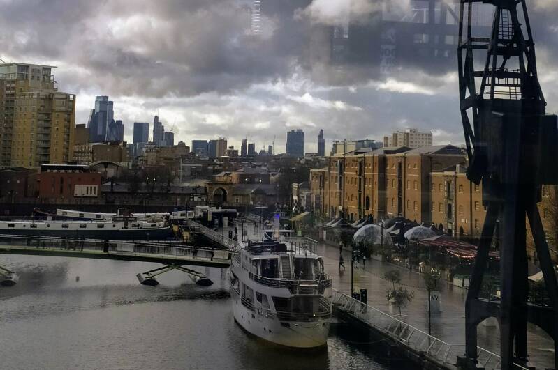
Gleaming towers, millions and millions of square meters of offices. Vasts expanses of water:I t used to be compared to WALL STREET, and to VENICE!

NORTH QUAY. CONVERTED WAREHOUSES

When you visit the NEW BILLINGSGATE MARKET you will have to see this piece of public art:  the TRAFFIC LIGHTS TREE


From the quayside you can reach the DLR station, on the viaduct, or , walking a little further  East access the ELIZABETH LINE, and also to cafes, restaurants, cinemas, etc. of this building by NORMAN FOSTER’s architectural practice. It opened in 2021.  You will be in CROSSRAIL PLACECROSSRAIL is the technical name by which the new railway line was known, before it was baptised in honour of Queen Elizabeth II.  Do not miss the rooftop garden!.

From up there you will see better the district dedicated to medical and live sciences, and the London wholesale fish market, NEW BILLINGSGATE, which was located here in the 1980s. You can visit it, and get some lessons of how to cook fish!. 


Or you can cross the FLOATING bridge that crosses the originally called EXPORT DOCK (now, the NORTH DOCK) and, alongside the other side, access CROSSRAIL PLACE, passing the MARKET HALLS.

Or you can head to CABOT SQUARE and enter the first shopping center, CABOT PLACE (remember that the other malls are connected underground, between them and the CANARY WHARF LU station). 


You are in a district that when it was born was destined to be the “second” financial area. A second CITY.

The ONE CANADA SQUARE tower, by the US-Argentinian architect CÉSAR PELLI, is the most  iconic building of the area (only look at the logo of the development) and in 1991 it became the tallest building in London and the second in Europe. The majority of the buildings within the CANARY WHARF ESTATE are offices (note many familiar names and logos), but, on the other hand, a good part of the skyscrapers further South (South of the SOUTH DOCK, closer to the MILLWALL DOCKS>>>>) are residential. This is called  nowadays in London “MANHATTAN STYLE LIVING”.
And WOOD WHARF >>>>, which belongs to the Estate, to the East, is mostly residential.

And, furthermore, in the western part of CANARY WHARF, the NEWFOUNLAND and the LANDMARK are both high-end apartments. Between the two, curiously, you see an office tower, the headquarters of SOCIÉTÉ GÉNÉRALE and the EUROPEAN BANK FOR RECONSTRUCTION AND DEVELOPMENT.

The oblong building without clear openings and that looks like floating on the dock, 12 BANK STREET, is a private members club.

The development of the district has not been uniform along the years. In times of recession nothing was build. The two towers both sides of ONE CANADA SWUARE were finished in 2003.
A curious piece of information: before the transformation into a financial centre began, CANARY WHARF had already attracted companies, which began to occupy old warehouses or other buildings.. A company that was based here during the 80s was LIMEHOUSE TELEVISION STUDIOS, which produced the famous program SPITTING IMAGES here.

Enjoy the JUBILEE GARDENS, above the LU station, and will find an entrance to the JUBILEE PLACE.

The station is pretty spectacular, especially the roof of the main entrance. And inside, a huge cavern, so big that the ONE CANADA  SQUARE building could fit inside, lying down, of course. Taking into account that the station was build on the site of the empty IMPORT (now MIDDLE DOCK) that means that they did not have to dig so much out as the hole was already there!.  

Precisely the MIDDLE DOCK  has been recently remodelled, the quayside becoming closer and more accessible,  so this has become an even nicer area.


To ISLAND GARDENS (for GREENWICH)                                   alongside the MILLWALL DOCK

On the map, WEST WINTER GARDENS. You can see the bridge over the SOUTH QUAY

A SCDS is sited in BANK STREET and UPPER BANK ST. West and East, respectively, of the JUBILEE GARDENS, an below the HERON QUAYS DLR station.

From the CANARY WHARF area, more specifically, from the EAST WINTERGARDEN or the WEST WINTERGARDENS (
to the South of the JUBILEE GARDENS), there is access to the footbridge over the SOUTH QUAY.

This side is becoming increasingly residential, bar some offices and hotels. There are restaurants and cafés, and a little street food piazza.

Note the WARDIAN development, in which the luxury apartments  enjoy generous balconies-conservatories where the owners can design their own opulent, if relatively small, sky-gardens. The name comes from NATHANIEL BAGSHAW WARD, the scientist (in fact he was a doctor, but became an explorer and botanist) who invented the WARDIAN CASE, a method of transporting plants safely from long distant lands. He practised medicine from his surgery in <<<<WELLCLOSE SQUARE, and put his knowledge to the service of the poor Eastenders.


You will go along the dock and head South (right) and heading towards the SOUTH QUAY station of the DLR. This area suffered in 1996 a terrorist attack by the way of an IRA BOMB that killed two people, and many more were hurt. One building had to be demolished. The bombing ended the ceasefire that the armed organisation had called previously.

Once you pass under the tracks, you only have to walk  along the MILWALL DOCK, where you will find cafés and restaurants.  And you can stop in the area of ​​PEPPER STREET and the GLENGALL BRIGE, as you will like it, since it looks like the street of a provincial seafaring town.

The MILLWALL DOCK was a different initiative, under different ownership. It entered operation in 1868, although the COMPANY was formed 2 years later. It dealt mostly with grain  (Mc DOUGALL) and timber.  You are walking along the INNER DOCK, but you could continue walking along the OUTER one. At the SE corner of this last, the former GRAVING DOCK (for repairs) is now an empty marina —the CLIPPER QUAY— surrounded by charming housing.

Most part of the DOCK is surrounded by housing, but there are still some offices buildings. For you to see how the DOCKLANDS are changing, look at that ARENA building you are passing by. The name, in fact, refers to the huge indoor LONDON DOCKLANDS ARENA which stood here for almost 20 years.


Towards the end of the dock, you will turn left and go under the DLR tracks, emerging on the road. Opposite, you will find the entrance to  the MUDCHUTE CITY FARM (an urban farm, ideal attraction for children, where you will find a café  and a WORLD WAR TWO anti aircraft gun).

When you come off the farm, South Side, MILLWALL PARK is waiting for you, and  following the old train viaduct (in use by the DLR trains until 1999) you will arrive to ISLAND GARDENS DLR STATION. Note the FRANK DOBSON’s sculpture WOMAN AND FISH. In fact is a replica, as the original was vandalised, when it used to be the centrepiece of a housing estate.

Finally, at the Southern tip of the ISLE OF DOGS you are going to find the ISLAND GARDENS.

By the way,  MUDCHUTE is a place name that emerged from the fact that mud, or earth from the dock was “shooted” or dumped over the place, when it was dredged.

You just have to go down the stairs or by the lift, follow the tunnel under the THAMES and, voilà!, you will be in GREENWICH. And the QUEEN'S HOUSE, part of the MARITIME MUSEUM, you can admire the famous painting that CANALETTO emulating the same view that you have enjoyed from ISLAND GARDENS.

The GREENWICH FOOT TUNNEL dates from 1902, and allowed the dockers and others to cross the river (remember that TOWER BRIDGE is the only bridge on the East side of the metropolis). You will notice the area which had to be repaired, due to bomb damage.


Why not continue the walk or ride around the “ISLE”? >>>>.


Buses to/from ISLAND GARDENS. The DLR STATION is by the main road


Walking or cycling the Thames Path,                 towards ISLAND GARDENS


Same destination as the last chapter… but a different route.

On the map, the CASCADES residential building


From CANARY WHARF to ISLAND GARDENS you are going to be walking, or cycling, following, the THAMES PATH, almost  the entire bank of the THAMES from LIMEHOUSE. The neighbourhood is called, in the western part of the ISLE OF DOGS, MILLWALL.

At the start, perhaps the bridge over the former lock that used to give access to the SOUTH DOCK is not open. In this case you only have to follow the walkways along the streets, heading  to the feet  of the CASCADES building, which shows modern features , but also  details of an old port warehouse and nautical motives. It is project from the W of DWZG (REX WILKINSON). In 1988 this became the first privately developed high rise building in the ISLE OF DOGS.
Note that for most of the walk you will see homes, some with a more interesting design than others. Nothing exceptional.

You will pass the park named in honor of the owner of the flour mill that was beside the MILLWALL DOCK, and local benefactor, SIR JOHN McDOUGALL.

Again, you will have to separate a little from the river bank, at ARNHEM WHARF, where you will walk beside the school. ARNHEM is a Dutch town where an important battle took place during WW2. Then, on the WESTFERRY RD. you will cross the site of the lock that allowed ships to access the MILLWALL DOCKS system. On WESTFERRY ROAD, look for THE SPACE, an arts and performance centre, converted from a SCOTTISH PRESBYTERIAN church (testimony of the Scots whowere living and working around here).

An empty plot is pending development. A project exists… This area was occupied from the 80s by the biggest printing works in Europe, where the some of the most important dailies of the UK were printed. You can pay a visit and join the DOCKLANDS SAILING AND WATERSPORTS CENTRE

 As soon as you can, through MAST HOUSE TERRACE and FERGUSON CLOSE, return to the THAMES PATH and continue ahead.

You will almost immediately pass by the place - BURRELLS WHARF - where ISAMBARD KINGDOM BRUNEL supervised the construction and launching, in  1858, of the SS GREAT EASTERN, the largest ironship in the world ever built until then. This happened 15 years after the <<<<THAMES TUNNEL, designed by his father MARC, and culminated by himself, was opened. You can see part of the     timber slipway. The complex was then owned by MILLWALL IRON WORKS of JOHN SCOTT RUSSELL. 
It took 3 months to float her sideways  into the Thames, as she was 629ft long!. And DICKENS was present!.  
It had a short span of service as a passenger and cargo ship. It was put to work laying Atlantic cables, and it was broken up in 1888.

After the demise of shipbuilding on the THAMES,  BURRELL’S COLOUR BUSINESS (dyes and pigments) took over for the best part of the 20th c. (until the 1980s). It was converted into residential.

The former OFFICES, the PLATE HOUSE and, on the main road) the FORGE, are listed buildings, converted to residential.

A SBDS is by the slipway.

Back around the main road, do not miss the LCC development of social housing, built for returned soldiers:  HOUSES FOR THE HEROIS. Lovely streets.

And the FIRE BRIGADE STATION has become a restaurant. 


Continuing along the river path (although towards the end you will follow the streets, since the embankment is occupied by private housing estates) you will pass THE FERRY HOUSE pub, on FERRY STREET, which reminds you of the existence here of a ferry or boatman since medieval times. And, finally, after the JOHNSON DRAW DOCK and the ROWING CLUB, you will arrive at ISLAND GARDERNS.


The entire route you have followed is replicated inland by the WESTFERRY ROAD (served by the buses), where you will find shops and cafes, the aforementioned SPACE, as well as some othe  historical industrial buildings, a Catholic Church, an LCC school  and social housing by the same institution. Or the former MILLWALL fire brigade headquarters, now a restaurant.

By the road, ISLAND GARDENS DLR station (for GREENWICH or back towards the CITY) and the buses will take you to the CITY, CANARY WHARF, LIMEHOUSE, POPLAR or to COLDHARBOUR, where there is a large ASDA supermarket and you will be very close to the MILLWALL DOCK and the CITY FARM. 
By ISLAND GARDENS a SCDS.


The Thames Path:                                                     from ISLAND GARDENS to BLACKWALL

DAN FARSON’s pub

ISLAND GARDENS DLR station

And finally…
You can complete the entire shore of the ISLE OF DOGS, after ISLAND GARDENS. Some former warehouses and draw docks are what you will see, but above all, again, contemporary apartments  and houses, although on the more inland side social housing dominates, forming not so attractive COUNCIL ESTATES.
Because of the BLITZ, few original Victorian buildings remain, such as CHRISTCHURCH, ISLE OF DOGS, or the WATERMAN'S ARMS pub and hotel.
This last place deserves some attention since it was owned by a somewhat mythical character in London, DAN FARSON, a writer, journalist, pioneer of the most daring television interviews... He dealt, in his books, with the bohemian life of Soho, and the East End, with crime, and with the history of MUSIC HALL.
In fact, he acquired this pub and turned it into a music hall and later into a jazz venue, where famous artists performed and where celebrities from all over the world attended the shows.


Carry on, on the river path: a “Dutch” style development of town-houses also stands out.

The neighbourhood you are visiting is CUBITT TOWN; The name is due to the person who designed and built it, SIR WILLIAM CUBITT, from a family of builders and engineers, who would also be LORD MAYOR of the CITY. You will hear a lot about the CUBITTs when it comes to building London, but pay attention, in fact there were two important families with that name.

You will pass an original PUMPING STATION to evacuate excess water on the docks, in case of a storm.

Then, the attractive white apartment blocks and the Victorian local offices of the CANAL & RIVER TRUST, the non-profit charity  that runs Britain's canals, as well as this former dock areas (you are still going to see a few signs from the time of BRITISH WATERWAYS, the public body who run the canals previously).
You will cross, separating yourself a little bit from the river, the BLUE BRIDGE (opened in 1969), inspired in a traditional Dutch bascule or draw bridge, over the lock that allows entry to the SOUTH DOCK, still in use. Immediately after that, to your right, you will enter COLDHARBOUR (street) and you will not miss THE GUN pub. It has a fantastic terrace.

COLDHARBOUR is a place name that originates in sites that used as a plain, simple shelter.

Follow the street and discover its Georgian and Victorian buildings. You will recognise the old police station. And NELSON HOUSE (I seems that the victorious admiral and his lover, LADY HAMILTON, used this dwelling). Pure legend. What about a tunnel between the house and the pub?.

The street returns you  to the main road, PRESTONS'S ROAD.


Alongside the main road

To WOOD WHARF, JUBILEE GARDENS and CANARY WHARF LU STATION

At this level you could enter the new WOOD WHARF development, belonging to the CANARY WHARF ESTATE. Before, though, have a look at the BLACKWALL BASIN and POPLAR DOCK MARINA, residential docks, in buildings and on boats. In the old times would have been filled with ships being built, with coal barges, and surrounded by industrial buildings and railway lines

You will notice that WOOD WHARF is predominantly residential. It even has typical London garden squares. The iconic building is ONE PARK DRIVE, designed by Swiss architects HERZOG & DE MEURON (who designed the restoration and conversion of the BANKSIDE POWER STATION into TATE MODERN (opened in 2000), and more recently created the new TATE wing (2019].

If you walk or cycle across  the WOOD WHARF district  (definitely, wood was unloaded around this area) Westwards  and head to the main entrance of the CANARY WHARF LU station you will enjoy the JUBILEE GARDENS and JUBILEE PLACE, the underground shopping centre.

The JUBILEE LINE  arrived here much late, in 2000, with respect to the opening of the complex. The interior of the station is impressive, thought 

40 years ago there was (there is still a portion, look at the old maps) one of the 3 docks of the WEST INDIA system, the IMPORT DOCK (now called MIDDLE DOCK). Therefore, to create the station, they did not had to dig as much…

To the right of the station the firmer REUTERS headquarters have been refurbished, and planting has been added to the façade, a not very usual feature in an office building.  And this end of the dock has been transformed improving the appearance of the place. In the background, the building with few openings is a private club.

If you are in the gardens you will find the bus stops in BANK STREET, 50 m. from the exit of the mall.. Route D3  takes you to LIMEHOUSE and WAPPING. The 277 to LIMEHOUSE and VICTORIA PARK and HACKNEY. The D7 to MILE END. The 135 to the CITY.
The buses going in the opposite direction (POPLAR, CROSSHARBOUR, ISLAND GARDENS) stop in front of  WEST  WINTERGARDENS.


Apart from the JUBILEE LINE, of course. The new ELIZABETH LINE, with its fantastic station, is 10m away. And you have 2 DLR stations, 5 min. away.


To BLACKWALL and POPLAR


Remember when you were exiting in COLDHARBOUR, at the entrance of WOOD WHARF. I bet you have had a beer at  THE GUN. Here's another idea...

You could go to POPLAR and also to BLACKWALL and the EAST INDIA DOCKS.

The D6 takes you to POPLAR from PRESTON'S ROAD. But you can also go on foot, through the POPLAR DOCK MARINA, walking alongside the water,  behind the wall on the left, then crossing the highway on a nicely developed SUBWAY, which will take you to the foot of the BLACKWALL DLR station. and the last stop of bus 15, and finally, you will continue straight along POPLAR HIGH ST>>>>.

However, first I recommend BLACKWALL>>>>.


And up to here the ISLE OF DOGS


BLACKWALL

On the map: when you get here, you are walking towards the THAMES, following the line of the GREENWICH MERIDIAN. You are heading East, towards the 3 peninsulas created by the LEA

You have to walk along PRESTON'S ROAD. Follow FAIRMONT AVENUE around the apartments, and you will come out onto BLACKWALL WAY, passing one of the ventilation towers of the BLACKWALL TUNNEL.

You will pass the former THOMSON REUTERS database, but now it is from TELEHOUSE. A typical high tech building from the ROGERS architectural partnership. And there is a clue to find out who the previous occupant of the building was: the  JOHN JULIUS CLOSE street plaque

JOHN JULIUS REUTER was the founder of the news agency, at the ROYAL EXCHANGE PLACE, in the CITY. There you will find a BUST in his memory. REUTERS’ historical HQ was on FLEET ST. It is now in CANARY WHARF, although it moved buildings in 2021.

Within the precinct (and normally not open to the public) there is an historic (built in 1607) dry dock, part of the BLACKWALL YARD, belonging to the EAST INDIA COMPANY, the company that had a monopoly on trade with the Indian subcontinent and the Far East and that, in fact, ruled India.


CITY. JOHN SMITH. MEMORIAL in ST.MARY-LE-BOW CHURCHYARD

CITY. PH near the site of the EIC Hq,  now occupied by LLOYDS OF LONDON


Continue until you reach the EAST INDIA DLR station. Then you will turn right and go towards the river, following the line of the GREENWICH MERIDIAN. When you reach the THAMES you cross the Meridian Line,  and of course, now you are on the EAST SIDE OF THE EARTH. You continue to the MEMORIAL TO THE FIRST SETTLERS OF VIRGINIA. 


The flag of the COMMONWEALTH OF VIRGINIA and the American flag also fly, together with the British and the English  flags, beside the MEMORIAL. From this area  a convoy of three English ships set sail heading to VIRGINIA, a territory already known, but not yet colonised. The voyagers became settlers, founding  JAMESTOWN. That happened  in 1607.
The first governor was called JOHN SMITH, does that sound familiar to you?. And what about that merchant who sailed,  in a different voyage (1609j and introduced a new type of seeds of tobacco into Virginia, the cultivation of which formed the basis of its economy, by the name of JOHN ROLFE... who would end up marrying an indigenous woman, but baptised Christian as REBECCA, but before  that called …POCAHONTAS!. 


One of the streets in the modern development is JAMESTOWN and others refer as well to this colonising adventure but if you look closely at the map you will see a PILGRIM MEWS. PILGRIM?. Which pilgrim?. Here they got confused: the PILGRIM FATHERS traveled some years later (1623) on a ship bound for Virginia but which was diverted from its route and they ended up disembarking in CAPE COD, currently MASSACHUSSETS, and finally founded NEW PLYMOUTH. The ship had sailed first  from ROTHERHITHE, on the South bank of the Thames, and from there to PLYMOUTH (DEVON). That ship was the MAYFLOWER and the MAYFLOWER pub  (ROTHERHITHE) commemorates that historical fact. One day you have to enjoy a beer there and visit the BRUNEL MUSEUM,  next door.  

Can you spot the difference?

Memorial to the FIRST COLONS

Now you are within the former precincts of the EAST INDIA DOCKS, from where the ships of the EAST INDIA COMPANY used to set sail towards the Indian Sub-Continent. After being build, repaired and provisioned here.
The valuable goods brought to London were taken to the warehouses on CUTLER ST. (CITY), on wagons, alongside  the EAST INDIA DOCK and COMMERCIAL ROADS, which were created precisely with this purpose.

The residential development that you have on the left occupies the land where there was the EXPORT DOCK (and later, until 40 years ago, the BRUNSWICK POWER STATION). The much larger IMPORT DOCK was behind it, to the North.
The trains brought here, as well, people  boarding ships to emigrate to AUSTRALIA.  That was in the 19th c.. They ate at the BRUNSWICK HOTEL, which was also the scene of the rather recreational meetings of the British governments in the Victorian era called the WHITEBAIT SUPPERS. You can still eat fresh whiting in some London pubs or some FISH&CHIPS restaurants. My favourite place is the TRAFALGAR TAVERN, in GREENWICH (the DLR takes you there from here!).

You will continue and reach the BASIN or the only former dock that still exists (now a wildlife sanctuary) after passing the lock bridge. Now the area has become a natural park. After the LOCK and the MILLENIUM BEACON, Continue straight ahead, and leave the precinct through the SALOME GATES, designed by the artist SIR ANTHONY CARO.


You are entering the LEAMOUTH area. The estuary or mouth of the LEA RIVER.

Of course, you can visit now LONDON CITY ISLAND>>>>


Walk Eastwards along ORCHARD PLACE and you will reach TRINITY BUOY WHARF, passing a residential development (2020), even if  the new apartment buildings look like warehouses.  Notice the repair dry dock, though, which is an historical relict. Now, it has been landscaped as a garden.

This area was part of ORCHARD HOUSE YARD, dedicated to shipbuilding during the second half of the 19th c.  The only known surviving vessel built at the yard is SS Robin, a 300-ton steam-powered coaster which is part of the National Historic Fleet and the last of her type still in existence. She was built at Orchard House Yard in 1890 by Mackenzie and is currently located a short distance away in the Royal Victoria Dock.

For more than 100 years nobody  has  been a living here. In Victorian times a community ,with churches, schools and taverns was living here, isolated, incomunicados, and with a high degree of endogamy.

TRINITY BUOY WHARF was the place where the CORPORATION OF THE TRINITY HOUSE (remember, based in TOWER HILL) experimented and manufactured the maritime signalling -buoys, lighthouses - destined to make England’s coasts safe for navigation, and trained its personnel. SIR MICHAEL FARADAY experimented here the first electrical lighthouse.
Nowadays, a creative and artistic cluster is  housed in a mix of Victorian buildings and converted shipping containers, around  which you will enjoy many artworks, and, in the same precinct, you will find places to eat and drink.

 
On the South bank of the THAMES, on the GREENWICH PENINSULA or NORTH GREENWICH,  you see another iconic building of London, THE O2, originally the MILLENIUM DOME. It was designed by the RICHARD ROGERS partnership and it was supposed to represent a symbol of the new millennium. It was the scene of a big NEW YEAR’S EVE PARTY in 1999, where the QUEEN and the Prime Minister TONY BLAIR welcomed the new Millenium.


Afterwards, a brilliant idea was put in motion: the opening of a spectacular exhibition to celebrate  humankind and the Third Millenium. 12 million visitors were expected, coming from the four corners of the world, but the real truth was pretty different, and disappointing. Only 6 million came.

After the closure of the exhibition, came years where the DOME became a white elephant. The very existence of this gigantic building was in doubt.  One of the proposals was pure and simple demolition.
Finally, in 2005, it was purchased by the ANSCHUTZ ENTERTAINMENT GROUP  which reached and agreement with the mobile phone provider company O2 giving it the naming rights of the venue.  And, as they say, the rest is history. No more a white elephant, but a very successful venue, at the centre of a new, upcoming neighbourhood.

The dome is one of the largest buildings by volume of useable space, in the world. And the actual structure is lighter than the weight of the the air contained in it!. Inside, apart from air, you will find the famous and huge O2 Arena, a smaller music venue, INDIGO, cinemas, bowling and restaurants and bars. 
And, on its top, you will get a fantastic view… seriously!: UP AT THE O2.

On the East side of TRINITY BUOY WHARF, another river, the LEA RIVER,  whose last stretch is called in fact BOW CREEK. On the other side of the CREEK, it had been the main site of the THAMES IRON WORKS, where warships and other types of vessels were built 100 years ago. This was the factory where WEST HAM UNITED FOOTBAL CLUB was born, IN 1895, the most representative club of East London, the Eastender club par excellence (the COCKNEY BOYS!). They are, of course, the HAMMERS. And the IRONS.  And look at the club badge: hammers. Precisely, it what you need at an iron works. The team had its first ground was on the other side of the river, now the MEMORIAL RECREATION GROUNDS. After 9 years they moved their base to the BOLEYN GROUND>>>>. Now the team plays in the LONDON STADIUM>>>>.


Backwards to LONDON CITY ISLAND and, across the RIVER LEA, to CANNING TOWN


Inevitably,  when you end your visit here,  you will have to retrace your steps, since you find yourself in a peninsula. When you arrive again at the SALOME GATES, why not turning right and have a look LONDON CITY ISLAND (in fact, a peninsula, again!), a development fully open since 2019, with apartments and some offices and cultural institutions (such as the headquarters of the ENGLISH NATIONAL BALLET, an art gallery and a cinema school). And, as usually, you will find some places to eat and drink. Historically, this peninsula was called GOODLUCK HOPE, the name used for the  contemporary de development along ORCHARD PLACE. At one stage, it was called LIMMO PENINSULA.

Of course,  you can decide instead  to take the bus D3 and return Westwards.

On the map, CANNING TOWN STATION


Public transport to/from CANNING TOWN

Walk across the peninsula, and, at its northern tip, you will find the RED BRIDGE that will allow you to cross the BOW CREEK  and reach CANNING TOWN, more precisely, the LU (JUBILEE LINE) and DLR, and bus stations.

CANNING TOWN is part of the LONDON BOROUGH OF NEWHAM, which is considered one of the most 
deprived local authorities in England. But not anymore the SECOND MOST deprived, as ITV used to be ranked only a few years ago.

The TOWN centre is nearby, alongside the BARKING RD., but it is not very attractive. The former TOWN HALL, where KEIR HARDIE, SYLVIA PANKHURST or WILL THORNE spoke, is a beautiful building.


The 330 bus will take you near the ROYAL VICTORIA DOCK, part of the ROYAL GROUP DOCKS, another dock system, at one time merged with the ST.KATHARINE’s. In fact, this docks were the largest group of enclosed in the world, with the largest man-made body of water. The whole area has been redevelopment and relandscaped as residential, business, educational and a leisure district.

You can visit CITY HALL, in a building easy to recognise, originally called THE CRYSTAL, created by SIEMENS as think tank and a centre for dissemination on the subject sustainability of cities.
Next door, you can jump on the CABLE CARwhich will take you a stone's throw from THE O2, in the GREENWICH PENINSULA.

Bus 330 continues its route until  it passes very close to the LONDON CITY AIRPORT, but especially is very handy if you want to get espectacular views of the THAMES BARRIER,  from the THAMES BARRIER PARK. I will deal with this area in a different web. However, one curiosity: you will be  in NORTH WOOLWICH, thus called because it was under jurisdiction of the BOROUGH OF WOOLWICH (based SOUTH of the THAMES), until 1965. WOOLWICH is now part of the ROYAL BOROUGH OF GREENWICH, and you will be forgiven if you think that you are in a GREENWICH district. But… nop!,  the NORTH WOOLWICH is part of NEWHAM.  Wait, wait… the PARK is managed by GREENWICH, not by NEWHAM. One of those London eccentricities…

East side of the Lea, West side of the Lea. 

Remember that you were on the other side of the RED BRIDGE?. Now, you decide to enter BOW CREEK ECOLOGY PARK, on ​​the neighbouring peninsula, to the West; so you have to turn left. You will see that the DLR passes the the ecological park, the whole length of the peninsula, but, mind you, here is no station. After seeing this small park, another bridge is going to take you over the LEE, and you will head towards the EAST INDIA DOCK BASIN or to EAST INDIA DLR station, alongside the path following the LEA bank.

And still more nature…

Remember when you were coming back from TRINITY BUOY WHARF, but you decide to through the SALOME GATES again?.  Then you can choose to visit the EAST INDIA DOCK BASIN and enjoy, also here, a nature reserve, and then, going around this old dock, head towards the EAST INDIA DLR station.

The park is run by the LEA VALLEY REGIONAL PARK. You are visiting a fraction of that park, of the LEA VALLEY, South of the OLYMPIC PARK. To North of this one the bigger part of the LVRP is going to receive a mention, and a future web is going to deal with it.


In order to go to the DLR station following this route, you have to pass through the site  of the old IMPORT DOCK, where now you will see offices and data centres . In fact, the TOWER HAMLETS TOWN HALL was located here, before moving to the  <<<<ROYAL LONDON HOSPITAL 18th c. buildings. And you will find a couple of bars, as well.


Inside the precinct there is  an access to the EAST INDIA station by means of a walkway 

The Victorian map gives you idea of how the area looked like

On the map, NAVAL ROW, on your way towards POPLAR. To the left, you can see ALL SAINTS CHURCH


If you still feel strong, you could walk to POPLAR. You will leave the precinct going passing under an arch through the high walls of the old port complex.

You will note a water pumping station and you will follow NAVAL ROW. A closed  dockers pub looks  derelict.
You will pass the entrances to the BLACKWALL TUNNELS on your right, and on the left, a roundabout with the bus 15 end of the route stop and the BLACKWALL DLR station. SCDS. And then you can continue along POPLAR HIGH STREET, passing what is left of ROBIN HOOD GARDENS, a grey and ugly and discredited COUNCIL ESTATE in the process of being demolished. A fragment, though, has been acquired by the V&A MUSEUM, to be exhibited, as it is considered an iconic BRUTALIST building.
Soon you will see, to the right, the church of ALL SAINTS, POPLAR>>>>.  And then you will arrive at the old TOWN HALL of POPLAR, now the LANSBURY HOTEL>>>>.


And that is all about BLACKWALL


POPLAR

On the map, the CHRISP STREET MARKET SQUARE

You can also get here on, amongst others, bus routes 15, 115 or 135, on D6 or  D7 (from MILE END), D7 (from CANARY WHARF)  and on the DLR (CHRISP STREET station).

POPLAR was a London borough in itself. You are going to find some old plaques reminding you of this status. POPLAR became part of the L.B. of TOWER HAMLETS in 1965


POPLAR, another typical Eastender district, traditional home to the popular classes, which nobody would have  visited a few years ago,  but which has some charms and points of interest.


Since you are in the central part of the district,  the first building that catches your eye is that large brown brick one, with some DECO elements: the former PUBLIC BATHS. One  of those public buildings, or institutions,  that are found in all the districts of London (the people of the working classes did not  have a complete bathroom in the house, until the post-War period;  there was only a W.C in the garden of the house, which was shared by all the households living in the building. The PUBLIC BATHS building is now, fully renovated,  a LEISURE CENTER, with swimming pool, gym, etc.


Opposite the entrance of the Leisure Centre, the STATUE OF RICHARD GREEN, local shipowner and philanthropist. The dog accompanying him has only one ear. ear. A local boy who had jumped on the monument got a hand caught  inside a tight corner (naughty!) and the fire fighters had to cut the ear…

In EAST INDIA DOCK RD., a little further west, you willsee the firmer Victorian school that his father, GEORGE, contributed to fund and endow. Now, POPLAR HARCA offices (the housing association that runs most of the former council estates of the area)  occupy the building.

Notice the FESTIVAL OF BRITAIN logo on a drain. You will see some more reminders of the on the orinal buildings of the  LANSBURY estate


On the North pavement and development is where
you will most of the social life of the area, with the  shops, banks, restaurants, cafés, and the IDEA STORE (library).

You are now entering now a postwar development that was intended as a model  of new architecture for SOCIAL HOUSING. In fact, it was opened as an "open air museum" during the 1951 FESTIVAL OF BRITAIN, organised to showroom the prospects of a better  life in the United Kingdom, still affected by war era the restrictions and by the physical consequences of the recent bombardments, that had left the housing of the metropolis seriously decimated. The SOUTH BANK CENTRE has, as its most iconic building, one of the few survivals of the 1951 event, the ROYAL FESTIVAL HALL.

Except for SUNDAYS, in the central plaza CHRISP STREET MARKET takes centre stage, a typical street market of the EAST END of London. And a couple of small cafés  serve authentic CURRIES  and other types of  world food.
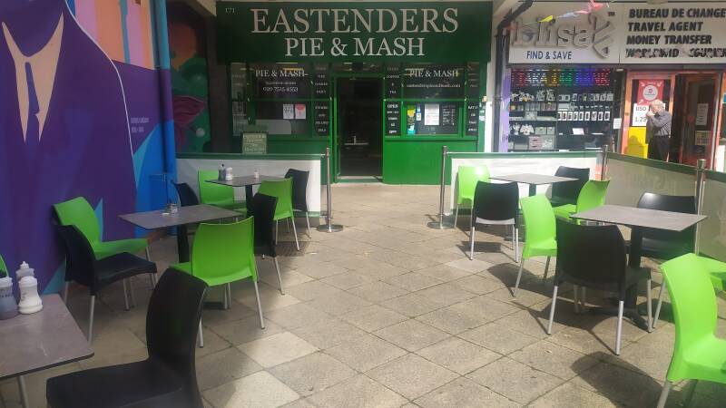
Note that EASTENDERS, on this side of the main road, serve PIE & MASH and JELLIED EELS, 
typical dishes of the EAST END and other London working class neighbourhoods.

From the centre of te market, if you look Eastwards, you will recognise, one mile or so away, the 1967  BALFRON TOWER, an iconic London building, sister to the TRELLICK TOWER of NOTTING HILL. The Hungarian ËRNO GOLDFINGER was the architect that designed both those publicly developed residential towers, in a BRUTALIST style. Both would become magnets for crime, delinquency, drug trafficking… both areas became rundown. Both buildings were finally sold off by the local authority, they have been renovated  and now are magnets for gentrification.

In fact, BALFRON is accompanied by the CARRADALE tower, and are examples of a MODERNIST style called BRUTALISM (from the French BRUT, as it is mostly concrete , BETON BRUT,  what it is on view). 

GOLDFINGER’s buildings were not the cup of tea of IAN FLEMING, and that is why he created the famous evil character, GOLDFINGER, of JAMES BOND fame. Obviously the architect did not appreciate the link (he received nasty letters and phone calls) and the matter had to be settled in court.


The so-called open-air museum, initiated in 51, has been enlarged  and is still being added new buildings . In fact you are visiting the LANSBURY ESTATE, originally a COUNCIL ESTATE, but now it is not run anymore by TOWER HAMLETS, but by various HOUSING ASSOCIATIONS. If you see the plaques (or the maintenance vans)  of  POPLAR HARCA o TOWER HAMLETS HOMES around, do not be surprised.

Moving North: to LANGDON PARK

Moving North: to BARTLETT PARK

On the map, the POPLAR UNION, on BARTLETT PARK


To the Northwest of the LANSBURY ESTATE, walking or cycling towards LIMEHOUSE, you will cross through BARTLETT PARK, bordered by the course of the LIMEHOUSE CUT.  A contemporary  development was erected around the former ST. SAVIOUR’S church, Victorian, converted into living quarters, The former church is  only survival of the terraces of houses, shops, pubs (note the surviving former corner pub), factories… that were here before the BLITZ: the park did not exist!.  Bus route 309 serves the area . But, why tot having a coffee  at the POPLAR UNION café?. Events take place at this arts and community centre that has helped re landscape the park. 

Bus 309 serves this area

Alongside the towpath: <<<<ST ANNE’S, LIMEHOUSE is a mere 20 min. walk. THREE MILLS ISLANDS>>>>, half an hour. 

If you walk East 

On the map, ALL SAINTS church. To the South, the POPLAR HIGH STREET

POPLAR RATES REBELLION plaque 


Remember CALL THE MIDWIFE?. This MISSION HOUSE, in LODORE ST.,  served as inspiration for the show’S NONNATUS HOUSE

Towards POPLAR HIGH STREET


Remember, when you were on the main street, EAST INDIA DOCK RD. CANARY WHARF is on view.

EASTENDERS (PIE & MASH) behind you.  Your two next destinations could be:

The church to the left: this  is the parish church of POPLAR: ALL SAINTS, built at the beginning of the 19th century.
If you look to the other side, the RECREATIONAL GROUND, presided over by a MEMORIAL  to the CHILDREN who lost their life during a bombardment that destroyed their school.


After visiting the church, we recommend that you have a look this park, and then walk to LANSBURY HERITAGE HOTEL.

This building was, first the POPLAR DISTRICT BOARD, then POPLAR’S TOWN HALL 100 years ago.

Now, imagine in this place the Labour MAYOR GEORGE LANSBURY and his local government team (including two other members of his family) refusing to contribute to to the LONDON COUNTY COUNCIL budget, alleging that this district could not afford  the same amount of money that, for example, KENSINGTON, one of the wealthiest boroughs of the country.

Because their refusal, the leftist councillors were arrested and sentenced to imprisonment. After 6 weeks, thanks to the popular pressure, with the help of the unions and other local councils they were released. The POPLAR RATES REBELLION became inscribed as an important episode in the history of the wirking classes and of London.  
The rate (now, COUNCIL TAX) was the tax exacted by the boroughs, according to the value of each  property. A fraction of it plus the money collected from the PRECEPT were allocated by the borough to the L.C.C. in order to fund it and other common services (police, water works, social asylums).

The L.C.C  was abolished in 1965, when the GREATER LONDON COUNCIL  was put in place, by the same London Local Government Act of 1963 that created and put in place (from 1965] the current 33 local authorities of the metropolis (32 London Boroughs, including the City of Westminster, and the City of London).
This arrangement lasted until 1985, when the G.L.C. was abolished. The 33 authorities remained though.
And, finally, the GREATER LONDON AUTHORITY, was born in 2000, with the same territorial jurisdiction as the G.L.C., that is, a
bout 1600 km approximately or around 600 square miles

However, note that for 14 years Greater London did not have a local government a government running  the whole of the metropolis, thanks to the government of PM  MARGARET THATCHER, who saw the G.L.C as a too left-weaning institution and which represented a counterweight to her government.


And, by the way,  a new word was coined in those convulsed years: POPLARISM, that is, defiance on the part of local authorities.
GEORGE LANSBURY, in the 1930s, became LEADER of the LABOUR PARTY,  and even tried to influence inter war  international politics.
He was the father of ANGELA LANSBURY, the actress.


Behind the LANSBURY HOTEL there is a separate part of the park.  There is an access on WOODSTOCK TERRACE and another one on the HIGH ST.  Do not miss the former ST.MATHIAS church, which was founded and erected by the EAST INDIA COMPANY, in the c.17. Currently is a community center and a crèche or daycare centre for infants.


If you follow the HIGH STREET Westwards, note the former LIBRARY and the former ENGINEERING AND NAVIGATION SCHOOL, now NEW CITY COLLEGE. The former institution is where a young ALFRED HITCHCOCK  learned matters  of electricity that became very helpful for his future cinema career, according to his own memoirs. He was living with his family in SALMON LANE, where his father run two businesses.

After the modern college building you will find a path towards the  DLR POPLAR station and, that same bridge will take you over the DLR tracks,  giving  you access to the CANARY WHARF ESTATE. At your feet the new HEALTH AND LIFE SCIENCES HUB.

The space now taken over by road were railway tracks, MING STREET was KING STREET.

The former DOCKMASTER’S HOUSE was, until the 1920s, the pub JAMAICA TAVERN

On the map, where the former DOCKMASTER HOUSE

Same place. What 100 years make…


POPLAR HIGH ST. becomes PENNYFIELDS, but you are branching left, into MING STREET.  And it is only through the names of some streets, like this one, of the area that the FIRST LONDON CHINATOWN is revealed to us. Otherwise we have to rescue the works of CHARLES DICKENS, OSCAR WILDE, ARTHUR CONAN DOYLE or SAX ROHMER, whose characters come here in search of the infamous opium dens. A poor, seedy, sinister, and criminal neighbourhood settled by an exotic “race” of dubious reputation, and evil by definition. This is a false notion that came to us for decades, through those authors, though.


You find yourself on the edges of POPLAR. And the roads here are incredibly large (the give access to the LIMEHOUSE LINK TUNNEL). The BLITZ here helped  the post war  administrators to plan a needless expansion of the streets and, as a consequence, the displacement of the small Chinese population, as old houses were pulled down.
Which explains the fact that the small community headed for SOHO. From the EAST END, to the WEST END, where many business, formerly occupied by European migrants, lay empty. Nowadays Greater London is home to more than 100,000 people of Chinese origin. Clearly SOHO’S CHINATOWN can not house all of them. And, by the way,  there is still a surviving  Chinese Sunday School surviving, in POPLAR. 

When you will be on the West side of the apartment building, opened  in 2022, which incorporates a PREMIER INN hotel, you will admire an artwork that reminds us of the Chinese heritage  of the area.


You are now  close to enter the <<<<WEST INDIA DOCKS; you need to go (East of the high rise building) under the DLR viaduct (by the way, the station is at the feet of that building).

CHINESE LEGACIES 
Photo from POPLAR LONDON


To your left, a CAR PARK, to your right the firmer DOCK MASTER'S HOUSE (see the P.L.A. plaque) now offices. Next, you see the pillars of the former gates of the WEST INDIA DOCKS precinct. Around this area,  the dockers were recruited, on a daily basis,, or the CALL ON. Employment, badly paid, was, in addition, very insecure.

Now you see the warehouses.: you are at the rear of the <<<<MUSEUM OF DOCKLANDS and the <<<<THE LEDGER BUIDING pub.   On the bend, the building to your right  was, again, a  P.L.A. building (plaque), but now is part of the POINT A hotel (whose reception and main building is 100 yards in front of you). And now you can see the foundation stone of the <<<<WEST INDIA DOCKS.

YOU are now in  the CANARY WHARF ESTATE.

POPLAR. Former Borough

And that was POPLAR and the LONDON DOCKLANDS

Create Your Own Website With Webador